
Submitting Data and Information for the Integrated Report
Table of Contents
- Data and Information Submittal Basics
- What are the general data and information submittal requirements?
- How is "readily available data and information" defined?
- What are CEDEN compatible data?
- Which data and information are not compatible with CEDEN?
- How should a QAPP or QAPP equivalent documentation be submitted?
- When should data and information be submitted?
- Who can submit data and information?
- What kind of data and information should be submitted?
- What kind of data and information should not be submitted?
- Instructions for Submitting CEDEN Compatible Data
- Instructions for Submitting non-CEDEN Compatible Data
- What if I have already submitted data to federal systems like the Water Quality Exchange?
- How will the data and information be evaluated for use?
The current data solicitation notice (available on the main program page) outlines which data from waterbodies will be considered for the current California Integrated Report. Please reference the California Integrated Report map for Regional Water Board information and appropriate contacts.
Data and Information Submittal Basics
The integrated report satisfies two of California's reporting requirements under the Clean Water Act ("CWA"). One is the CWA section 303(d) requirement to identify impaired waterbodies that are not meeting or not expected to meet water quality standards (commonly called the "303(d) list of impaired waters" or the "303(d) list"). The other is the CWA section 305(b) requirement to report on water quality conditions (commonly called the "305(b) report").
The 303(d) list is prepared in accordance with the Water Quality Control Policy for Developing California's Clean Water Act Section 303(d) List ("Listing Policy").
The State Water Resources Control Board ("State Water Board") administers the development of the California Integrated Report so that each integrated report consists primarily of assessments from three Regional Water Quality Control Boards ("Regional Water Boards") that are characterized as being "on-cycle" by a Notice of Public Solicitation of Water Quality Data and Information ("Data Solicitation Notice"). The other six Regional Water Boards are "off-cycle"; although they may assess high-priority data, make 303(d) listing or delisting recommendations, or propose changes to the 305(b) report. Every two years, the Regional Water Boards characterized as "on-cycle" are rotated so that each Regional Water Board is fully assessed once every six years. However, watersheds within the Central Valley Regional Water Board will be assessed each listing cycle in a rotating basin approach, regardless as to whether the region is "on-cycle" or "off-cycle" for a particular listing cycle. There are four watershed basins within the Central Valley Regional Water Board:
- Sacramento River
- San Joaquin River
- Sacramento – San Joaquin River Delta
- Tulare Lake Basin
Waterbodies within the Sacramento – San Joaquin River Delta and Tulare Lake Basin will be assessed concurrently.
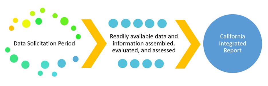
Each integrated report cycle begins with a Data Solicitation Notice distributed by the State Water Board. The Data Solicitation Notice identifies the upcoming cycle, lists the Regional Water Boards that are "on-cycle," and establishes a cut-off date by which all data and information should be submitted for consideration. The State and Regional Water Boards (collectively the "Water Boards") will consider all readily available data and information from each of the "on-cycle" regions. However, an integrated report may also include high priority data and information from "off-cycle" regions. Please visit the Surface Water Quality Assessment Program webpage for more information about the integrated report cycles.
"Readily available data and information" submitted during the data solicitation period will be assembled (e.g., gathered and organized), evaluated to consider whether or how data and information will be used and, if appropriate, assessed to determine surface water quality conditions and to identify impaired waters. Section 6.1.1 of the Listing Policy defines readily available data and information as data and information that can be submitted to the California Environmental Data Exchange Network ("CEDEN") or its successor database by the data solicitation cut-off date. If CEDEN is unable to accept a particular subset of data and information, the Water Boards will accept that data and information if it meets the formatting and quality assurance requirements detailed in section 6.1.4 of the Listing Policy.
Instructions for submitting data and information for the integrated report are provided below. To be considered for the integrated report, data and information submissions must include the minimum data elements required for assessment and be received by the deadline identified in the Data Solicitation Notice. See the "Instructions for Submitting CEDEN Compatible Data" and the "Instructions for Submitting non-CEDEN Compatible Data" sections below for the minimum data elements required and instructions for submitting data and information.
The State Water Board encourages continuous submittal of data and information for any surface waterbody in California because the State Water Board may evaluate data and information at its discretion.
What are the general data and information submittal requirements?
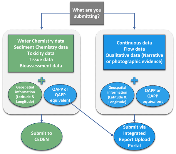
The figure below illustrates the process for submitting data and information for the Integrated report. Data that can be accepted by the California Environmental Data Exchange Network ("CEDEN"") must be submitted to CEDEN. Data and information that are not CEDEN compatible can be submitted via the Integrated Report Upload Portal.
Data and information submitters are encouraged to notify the State Water Board when submitting data and information to CEDEN or the Integrated Report Upload Portal. Water Board staff are available, on a limited basis, to conduct a cursory review of the data and information submittal for the minimum data elements and quality requirements. Please send an email to WQAssessment@waterboards.ca.gov with "Request for Assistance with Data and Information Submittal" in the subject line.
All data and information must also have a Quality Assurance Project Plan or Equivalent submitted to the Integrated Report Upload Portal, or the data and information cannot be used for integrated report assessments.
Section 6.1.4 of the Listing Policy states that data supported by a Quality Assurance Project Plan ("QAPP") or QAPP equivalent documentation are acceptable for use in developing the section 303(d) list. Data and information not accompanied by a QAPP or a QAPP equivalent documentation cannot be used as a primary line of evidence to support a 303(d) listing or delisting recommendation.
For more information on QAPP documentation, please see the requirements outlined at the IR Upload Portal webpage.
Section 6.1.4 of the Listing Policy includes an exclusive list of monitoring programs that are exempt from QAPP requirements. Commencing with the 2026 California Integrated Report, all data submitted by a monitoring program that is not explicitly listed in section 6.1.4 of the Listing Policy must be supported by a QAPP for that data to be used by itself to support a 303(d) list or delist decision for a water segment. Moreover, beginning with the 2026 303(d) List, even though data used from the explicitly listed major monitoring programs are considered adequate, State Water Board staff"s goal is to obtain QAPPs for such data.
Additionally, CEDEN does not store QAPP documents. The QAPP name and other summary information stored in CEDEN is not sufficient to determine if data or information are useable for integrated report assessments. All QAPP and QAPP equivalent documents must be uploaded to the IR Upload Portal. Please ensure all applicable Parent Project Name(s), Project Name(s), and/or Project Code(s) are the same for the data or information and the corresponding QAPP or QAPP equivalent document.
How is “readily available data and information” defined?
The Listing Policy defines "readily available data and information" as data and information that can be submitted to CEDEN prior to the cut-off date as directed in the Data Solicitation Notice. CEDEN-compatible data should be submitted to CEDEN. If CEDEN is unable to accept a particular subset of data and information (non-CEDEN compatible data and information), the State Water Board will accept that data and information through the IR Upload Portal if it meets the formatting and quality assurance requirements detailed in section 6.1.4 of the Listing Policy and the Data Solicitation Notice for the current listing cycle" (Listing Policy, Section 6.1.1.).
"Information" is considered to mean any documentation, such as narrative or photographic evidence, describing the water quality condition of a surface water body.
"Data" are considered to mean a subset of information that consist of reports detailing measurements of specific environmental characteristics (i.e., measurements of physical, chemical, or biological characteristics in aquatic environments).
What are CEDEN compatible data?
CEDEN compatible data sets include water chemistry, sediment chemistry, toxicity, tissue and bioassessment data, along with associated geospatial information (e.g., latitude, longitude of sampling locations). CEDEN compatible data must be submitted through CEDEN.
CEDEN accepts the following data types:
- Chemistry: laboratory results from water samples or sediment samples
- Field collection: measurements collected in the field, including data from field probes and habitat surveys
- Toxicity: laboratory results from water column or sediment toxicity tests
- Tissue: laboratory results from fish tissue or other tissue samples
- Bioassessment: habitat measures and observations, and measurements of biology such as benthic macroinvertebrate and algae taxonomy
For instructions on submitting data to CEDEN, refer to the Instructions for Submitting CEDEN Compatible Data. The CEDEN website is found here: http://ceden.org/303d_list.shtml.
Note that data and information not accompanied by a QAPP or QAPP equivalent documentation cannot be used as a primary line of evidence to support a 303(d) listing or delisting recommendation. For instructions on submitting a QAPP or QAPP equivalent documentation for CEDEN compatible data, see the IR Upload Portal webpage.
Which data and information are not compatible with CEDEN?
Data and information that are not CEDEN compatible include continuous or near-continuous monitoring data (e.g., data collected by an in-situ device) and narrative or photographic evidence. For instructions on submitting non-CEDEN compatible data, see the Instructions for Submitting non-CEDEN Compatible Data section below.
How should a QAPP or QAPP equivalent documentation be submitted?
QAPPs or QAPP equivalent documentation are submitted via the IR Upload Portal. As mentioned above, data not supported by a QAPP or equivalent cannot be used as primary line of evidence to make 303(d) listing or delisting decisions. For instructions on submitting a QAPP or QAPP equivalent documentation, see the IR Upload Portal webpage.
When should data and information be submitted?
Data and information can be uploaded to CEDEN or the Integrated Report Upload Portal at any time. The State Water Board recommends data and information be submitted early to reduce and to avoid backlogs in data and information uploading. However, data and information must be submitted by the data solicitation cut-off date and time outlined in the Data Solicitation Notice to be considered for the next integrated report. Data and information submitted after the data solicitation cut-off date will be considered the next time the Regional Water Board associated with the data or information is on cycle.
Who can submit data and information?
Any person or entity (including but not limited to private citizens; local, state, and federal governmental agencies; non-profit organizations; businesses; and tribes) possessing information regarding the quality of California’s waters may submit data and information.
What kind of data and information should be submitted?
Any data and information that contributes to a more complete understanding of the quality of the state’s surface waters should be submitted. This includes data and information that will help the Water Boards determine if water quality standards are being attained or not attained. Any data and information not submitted for a previous Integrated report cycle should be submitted. This includes data and information collected since the last data solicitation period as well as data and information collected prior to that date but not submitted.
The integrated report will include quantitative and qualitative information. The bulk of the data used in the integrated report is expected to be quantitative, or numeric. These data provide the basis to develop primary lines of evidence ("LOEs"). Qualitative information consists of non-numeric evidence such as photographs or narrative data. Qualitative information is used to develop ancillary LOEs, in some cases. For greater detail on how different data types are used, see section 3 of the Listing Policy (https://bit.ly/2015_ListingPolicy).
Data and information submitted may pertain to individual waterbody segments, entire waterbodies, or whole watersheds in California.
What kind of data and information should not be submitted?
Please do not submit:
- Data and information previously submitted as part of a past integrated report listing cycle.
- Data already submitted into CEDEN.
- Data and information pertaining to groundwater.
- Data and information from collection locations deemed not representative of ambient conditions in the waterbody segment (e.g., storm drain outfalls, effluent discharges).
- Data submitted directly to the United States Environmental Protection Agency ("U.S. EPA") via the Water Quality Exchange ("WQX").
Instructions for Submitting CEDEN Compatible Data
CEDEN is a central location to locate and share information about California"s waterbodies, including streams, lakes, rivers, beaches, and coastal ocean waters. Many groups in California monitor water quality, aquatic habitat, and wildlife health to ensure good stewardship of ecological resources. CEDEN aggregates these data and makes them accessible to environmental managers and the public.
The CEDEN website provides information about preparing and submitting data to CEDEN, including data templates that prescribe the CEDEN formats; detailed documentation that defines data elements; and lists that contain the current controlled vocabulary values that must be used in data submittals. Vocabulary that isn't currently listed can be requested through a vocabulary process, which is also outlined on the CEDEN website.
Note, a Parent Project Name must be registered in CEDEN prior to submittal. A Parent Project Name is the identifier that links similar monitoring projects from different monitoring groups across different years. It is important to use the correct Parent Project Name as this assists with the organization and accessibility of data in CEDEN. Information on registering a project is outlined on the website.
Access the CEDEN website: http://ceden.org/303d_list.shtml.
Note that, in addition to the CEDEN submission requirements, the following minimum data elements are required for integrated report assessments:
- Latitude and longitude of site locations. The Target Latitude and Target Longitude fields in CEDEN are used by the Water Boards' staff to map waterbodies and if these coordinates are inaccurate the data may not be assessed.
- Method detection limit ("MDL") and reporting limit ("RL"). These are especially important if data results include "non-detect" ("ND"), "detected not quantified" ("DNQ"), or "too numerous to count" ("TNC") notations.
- Quality assurance ("QA") codes, when applicable.
Assistance with uploading Data to CEDEN
Any interested party collecting water quality data in California can request assistance to submit data to CEDEN. Please send an email to ceden@waterboards.ca.gov.
Instructions for Submitting Non-CEDEN Compatible Data and Information
Data and information that cannot be uploaded into CEDEN must be submitted directly via the Integrated Report Upload Portal.
Prior to submitting data and information through the Integrated Report Upload Portal, please ensure the submittal includes the minimum data elements and information required for integrated report assessments as described below.
Numeric data and qualitative information must be in electronic format that can be manipulated by the Water Boards' staff for assembly and evaluation (e.g., spreadsheet, comma separated text file) and include the following minimum elements. Numeric data will not be assessed if submitted in portable document format ("PDF") or as a web link reference. Qualitative information (such as a photograph or narrative information) can be submitted as a PDF or image file (.jpeg, .tiff, etc.).
Each data set much include the following minimum data elements:
- Project name
- Contact information of person/organization submitting the data
- Applicable Regional Water Board
- Applicable pollutant categories
- Time-period over which the data were collected
- Summary of submittal or list of submittal contents and any instructions required for assessment, which may include:
- Definitions for codes or abbreviations used
- Whether additional summaries or instructions are attached to the cover sheet or where they are included in the submittal
- Sampling location information:
- Station Name(s)
- Station Code(s) (if available)
- Latitude and longitude
Numeric data must also include the following minimum data elements:
- Date and time of measurements
- Number of samples
- Analytes
- Units of measurement
- Method detection limit ("MDL") and reporting limit ("RL"). These are especially important if data results include "non-detect" ("ND"), "detected not quantified" ("DNQ"), or "too numerous to count" ("TNC") notations.
- Quality assurance ("QA") codes, when applicable
- Supporting or associated analytical data (e.g., hardness data with dissolved metals samples; temperature; salinity; and pH data with ammonia measurements)
- Other relevant factors
Qualitative information must also include the following minimum elements:
- Describe events or conditions that indicate impacts on water quality
- Provide linkage between the measurement endpoint (e.g., a study that may have been performed for some other purpose) and the water quality standard of interest
- Be scientifically defensible
- Provide analyst's credentials and training
- Be verifiable by the Water Boards' staff
Photographic documentation must include of the following minimum elements:
- Date and time photograph(s) were taken
- Spatial representation of the photographs, (e.g., reach, location)
- Temporal representation, (e.g., time of year)
- Linkage between photograph-represented condition and condition that indicates impacts on water quality
- Rationale for area photographed and camera settings used
- Any additional pertinent information about the photograph(s) to support assessment
It is crucial all Integrated Report Upload Portal fields are filled out prior to submittal. Incomplete submittals will be deleted. Double check for accuracy and save submittal receipt and Submittal Application ID for submittal records.
What if I have already submitted data to federal systems like the Water Quality Exchange data system?
The Water Boards recognize that federal, agencies, tribal, and other entities submit data directly to the U.S. EPA via the Water Quality Exchange ("WQX") and it is not reasonable to also require that those datasets be uploaded into CEDEN.
Consequently, the Water Boards' staff will pull data directly from the Water Quality Portal which connects to the WQX and attempt to translate that data into a CEDEN compatible format for use in the integrated report assessments. Datasets will only be used for the integrated report if they conform to the minimum data elements and quality requirements.
How will the data and information be evaluated for use?
After the end of the solicitation period, all data and information submitted will be assembled and evaluated for the minimum data elements, including quality requirements.
Water Boards' staff will review the data and information and ensure all data and information are accompanied by QAPP or QAPP equivalent documentation. Per section 6.1.4 of the Listing Policy: If the data collection and analysis is not supported by a QAPP (or equivalent) or if it is not possible to tell if the data collection and analysis were supported by a QAPP (or equivalent), then the data and information cannot not be used by itself to support listing or delisting of a water segment. However, data and information (even if not supported by a QAPP) may be used as part of a situation specific weight of evidence determination (Listing Policy sections 3.11 or 4.11).
Data and information will be screened for quality using an automated data quality estimator tool and reviewed by the Water Boards' staff. Data identified by the screening tool as inaccurate or of low quality may not be used as primary LOEs for assessment. Instances where data may not be used as primary LOEs include, but are not limited to:
- QAPP or QAPP equivalent documentation not provided or that does not meet the requirements.
- Data with inaccurate or missing spatial information (e.g., latitude and longitude).
- Data that are not temporally or spatially representative of the waterbody.
- Data that are not appropriate for assessment of ambient surface water quality (e.g., effluent, groundwater, air samples).
- Rejected data or data of poor quality (e.g., holding time violations, failed quality control checks).
- Data that are quality control measurements and not appropriate for assessment (e.g., laboratory duplicates, blanks from control samples, matrix spikes, surrogate measurements).
- Data where the sample value is less than the quantitation limit (e.g., non-detects and detected not quantified) and the quantitation limit is greater than the water quality standard, objective, criterion, or evaluation guideline.
