Elk River TMDL
Background
In 1998 the North Coast Regional Water Quality Control Board (Regional Water Board) and the U.S. Environmental Protection Agency listed the Elk River Watershed under the Clean Water Act Section 303(d) as a sediment-impaired waterbody.
Sediment discharges and sedimentation exceeded the water quality objectives for sediment, suspended material, settleable matter, and turbidity resulting in adverse impacts to several beneficial uses, including domestic water supplies (MUN), agricultural water supplies (AGR), cold water habitat (COLD); spawning, reproduction and early development (SPWN); rare, threatened, or endangered species (RARE), and recreation (REC-1 and REC-2). Sedimentation has also resulted in conditions of nuisance, including elevated rates of annual flooding, loss of property, loss of use of property, loss of access to property, and risk to human health and welfare.
Overview
In 2016, the Upper Elk Sediment Total Maximum Daily Load Action Plan (Action Plan) was adopted by the North Coast Regional Water Quality Control Board (Resolution No. R1-2016-0017). The Action Plan was approved by the State Water Resources Control Board in 2017 (Resolution No. 2017-0046), and was approved by the Office of Administrative Law and approved by the United States Environmental Protection Agency in 2018.
The goals of the Action Plan are to achieve sediment related water quality standards, establish a sediment load, identify a process for assessing and implementing remediation and restoration actions, and describe a program of implementation. The Action Plan was incorporated in the Water Quality Control Plan for the North Coast Region (Basin Plan) and identified three elements to achieve its goals: permitting of discharges of waste, an Elk River Recovery Assessment, and a Watershed Stewardship program.
Additional information on each of these elements is included in the “Implementation” section below. Additional information on TMDLs is available from both the State Water Resources Control Board TMDL Program and the North Coast TMDL Program.
The three elements of the Elk River TMDL Action Plan (Action Plan) program of implementation are: waste discharge requirements (WDRs), an Elk River Recovery Assessment, and a Watershed Stewardship Program.
WDRs-The primary regulatory mechanism used by the Regional Water Board to control the nonpoint source pollution in the Elk River watershed.
WDRs have been in place since 2006 for Humboldt Redwood Company (HRC) and Green Diamond Resource Company (Green Diamond), the two commercial timber companies operating in the Elk River Watershed. The WDRs currently in effect were adopted in 2019 for HRC and in 2020 for Green Diamond.
Elk River Recovery Assessment (Recovery Assessment)- A non-regulatory assessment of sediment remediation and channel restoration activities, which in combination with sediment load reductions, are necessary to improve hydraulic and sediment transport in the Elk River.
Funded by the State Water Resources Control Board, the Recovery Assessment was completed in 2019 by CalTrout with assistance from Northern Hydrology and Engineering (NHE) and Stillwater Sciences, and with the guidance of a Technical Advisory Committee. The Recovery Assessment uses models to assess watershed responses to reduced sediment loading from the upper watershed, and the implementation of various restoration approaches. It also provided the basis for the development of the Elk River Watershed Stewardship Program: Sediment Remediation and Habitat Rehabilitation Recovery Plan (Recovery Plan).
Funded by the Regional Water Board and completed in 2022 by CalTrout with technical assistance from NHE and Stillwater Sciences, the Recovery Plan builds on the tools developed in the Recovery Assessment. It serves as a blueprint for habitat restoration and recovery actions from just above the confluence of the North and South Fork Elk down to the Humboldt Bay.
Watershed Stewardship Program- A non-regulatory approach to engage stakeholders in developing collaborative planning to enhance conditions in the Elk River.
The Stewardship Program provides a framework for working with partners to develop and coordinate restoration and recovery actions, address health and safety concerns, and develop a Science and Coordinated Monitoring Workgroup. Stewardship Program goals are to:
- Seek common ground among diverse participants.
- Identify strategies and solutions to improve the hydrologic, water quality and habitat conditions of the Elk River, reduce nuisance flooding and improved public transportation routes during high water conditions, and improve residential and agricultural water supplies.
- Promote coordinated science and monitoring.
The Regional Water Board has been working with partners to aid in watershed restoration and recovery. Key project partners include California Trout (CalTrout) Northern Hydrology & Engineering, Stillwater Sciences, Humboldt County, the California Department of Fish and Wildlife, California Coastal Conservancy, the Elk River community, Humboldt Redwood Company, Green Diamond Resource Company and the Bureau of Land Management.
Health and Safety projects include identifying alternatives to reduce nuisance flooding including increased flooding along Elk River Road and addressing domestic and agricultural water supply needs to the upper watershed.
Between May 2022 and June 2023, three rounds of Elk River resident interviews were conducted by Regional Water Board staff. The open-ended interview questions were designed to address the topics of 100- year flood levels, road flooding, drinking water, and wastewater systems. Participants were given an opportunity to share personal experiences on each of these topics and to provide any solutions they saw for the watershed. Information shared during the interviews will help with future health and safety project efforts.
Nuisance Flooding
In September 2020, the Regional Water Board funded a technical memorandum on that included extreme flood events up to the 1% annual chance flood i.e., the FEMA 100 Year Flood Plain. The 1% Annual Chance Flood Elevation Estimates for the Lower Elk River, Humboldt County (100-year Flood Memo), was completed by Northern Hydrology and Engineering and was distributed to Humboldt County flood protection authorities and made publicly available.
Elk River Road
In 2023 the Regional Water Board funded Humboldt County to complete a Project Study Report (PSR) for Elk River Road flooding. A necessary first step, the PSR will identify solutions to address the road flooding along Elk River Road at Zanes Road, Berta Road and the flood curve (near the intersection of Wrigley Road and Elk River Road).
Regional Water Board staff continues to work with state and local programs (e.g., Safe and Affordable Funding for Equity and Resilience (SAFER) Drinking Water Program, the Division of Drinking Water, Division of Financial Assistance,) to find alternatives for sustainable drinking water solutions to the upper Elk watershed.
The Regional Water Board Elk River TMDL Action Plan supports long-term recovery through watershed restoration. Guided by the 2019 Elk River Recovery Assessment and the 2022 Elk River Recovery Plan, restoration project planning is currently underway in the lower portion of the watershed (identified as Planning Area 1 in the Elk River Recovery Plan).
With funding from the California Coastal Conservancy and technical support from the Regional Water Board, CDFW, and NOAA, the CalTrout Team is leading the development of proposed restoration projects. Additional project information can be found in the March 2023 Planning Area 1: 10% Design Report. A 65% Design Report is currently underway.The Science and Coordinated Monitoring Workgroup will help to guide the development of a coordinated monitoring program framework that includes key monitoring questions and implementation strategies. When formed, the workgroup will build upon existing monitoring efforts and management recommendations, including those in the Elk River Recovery Plan and the 2022 Upper Elk River Sediment TMDL 5-Year Review Staff Report.
The Elk River TMDL Action Plan establishes that the Regional Water Board staff evaluate TMDL implementation progress in 2021, 2026 and 2031. The first staff review was presented to the Regional Water Board in August 2022 during the Upper Elk River Sediment TMDL 5-Year Review. Findings and recommendations are found in Sections 6.1 and 6.2 of the Staff Report.
- Executive Officer’s Corrections Memorandum
- Revised TMDL Action Plan (clean)
- Revised TMDL Action Plan (strikeout-underline)
- Draft State Board Resolution Approving TMDL Action Plan
- Response to Comments
2017
August 17, 2017 Regional Water Board Information Item
On August 17, 2017, during the Regional Water Board meeting in Santa Rosa, there was an informational item providing updates of the Upper Elk River Sediment TMDL. The item covered the State Board approval of the TMDL Action Plan, the progress of the Elk River Recovery Assessment, and the status of the Elk River Watershed Stewardship Program. Below are links to documents related to the informational item:
State Board Approval
The State Water Resources Control Board hearing to approve the TMDL Action Plan is scheduled for August 1, 2017. The public comment period closed on Tuesday, January 17, 2017. Non-substantive revisions have been added to the TMDL Action Plan and these revisions are detailed in the Executive Officer’s Corrections Memorandum to the State Water Board.
State Water Board Meeting Agenda and associated documents will be posted ten (10) days before the scheduled hearing date. Please visit the web links below for additional information and access to associated documents.
- Signed Adopting Resolution No. R1-2016-0017
- Adopted TMDL Action Plan
- Executive Officer's Summary Report
- Revised Notice of Hearing
- Revised Proposed TMDL Action Plan (strikeout-underline version)
- Revised Proposed TMDL Action Plan (clean)
- Adopting Resolution
- Executive Office Summary Report
- Adopting Resolution
- Proposed Action Plan for the Upper Elk River Sediment TMDL
- Response to Comments , [Attachment 1 - Public Comment Letters], [ Attachment 2 - Staff Memo], [Attachment 2A-Attachment to Staff Memo], [Attachment 2B-Attachment to Staff Memo]
- Change Sheet to TMDL Action Plan
- Notice of Public Comment Period, Workshop, and Hearing
- Audio for February 5, 2016 Public Workshop
- Draft Basin Plan Amendment - Action Plan for the Upper Elk River Sediment TMDL (TMDL Action Plan)
- Upper Elk River: Technical Analysis for Sediment (Technical Report)
2016
Regional Water Board Adopted TMDL Action Plan
On May 12, 2016 the Regional Water Board adopted the Action Plan for the Upper Elk River Sediment TMDL as an amendment to the Water Quality Control Plan for the North Coast. Staff provided the Board with a summary of the April 7 meeting and the clarifying edits to the TMDL Action Plan. Board deliberations proceeded with the public record closed and no additional public comments. The adopted TMDL Action Plan will next receive a hearing before the State Water Resources Control Board with appropriate notices given, undergo review by the Office of Administrative Law, then go to the US Environmental Protection Agency for final approval.
May 12, 2016 Regional Water Board Hearing
The April 7, 2016 hearing concluded without a decision of the Board. Certain edits to the Upper Elk River TMDL Action Plan were contemplated by the Board toward the end of the hearing on April 7, 2016. Staff has reviewed and refined those. The edits reflect minor changes requested by Board members to clarify 1) how hillslope indicators and targets are used to inform Board decision-making; 2) that a load allocation does not constitute an effluent limitation or a waste load allocation and that the Board has discretion in implementing it in WDRs, waivers or other actions to reduce and eliminate waste discharges; and 3) that staff will review the sediment source analysis for the Upper Elk River, sediment deposition in the impacted reach and Lower Elk River, and the need for a Lower Elk River sediment TMDL, in its five year reassessment using Recovery Assessment tools and other available data, as appropriate. These edits are not substantive and fall within the logical outgrowth of the content previously noticed for this item. As expressed on April 7, 2016, the public hearing on this agenda item has been closed and no new testimony or evidence will be accepted. The Board will resume its deliberations on this matter on May 12, 2016 at the Wiyot Community Center in Loleta.
April 7, 2016 Regional Water Board Hearing, decision postponed
A hearing to consider adoption of the proposed Action Plan for the Upper Elk River Sediment TMDL was held on April 7, 2016 at the Eureka City Council Chambers. The agenda for this hearing and audio recording can be found on our webpage at:
The Action Plan for the Upper Elk River Sediment TMDL was Item 5 on the agenda. The documents associated with this item were:
February 5, 2016 Staff Workshop
The Upper Elk River Technical Analysis for Sediment (technical report) represents a comprehensive assessment of sediment conditions and associated beneficial uses in the Elk River Watershed, and presents the best available and relevant science. The Technical Report describes the Elk River Watershed setting, the applicable regulatory framework, and desired watershed conditions. It further documents the sediment impairments, identifies and quantifies the sources of excess sediment, and estimates the sediment loading capacity of the system, distinguishing between current and future sediment loading capacity. Finally, the Technical Report proposes a TMDL for sediment as supported by the existing data, as well as a framework for implementation, monitoring, and adaptive management.
Please Note: The documents available for public review and comments are 1. TMDL Action Plan and 2. Technical Report. Comments on the Technical Report submitted in association with review of the draft WDR for HRC need not be repeated as part of comments on the draft TMDL Action Plan. Commenters are requested to simply provide reference to any previously submitted comments.
In July 2013, the North Coast Regional Water Quality Control Board (Regional Water Board) made available to the public via its website the Peer Review Draft Staff Report to Support the Technical Sediment Total Maximum Daily Load (TMDL) for the Upper Elk River (Peer Review Draft Staff Report). The document is accompanied by the peer reviewers' curricula vitae, their individual comment letters, and the Regional Water Board's responses to peer review comments.
Public Comment Letters Received for Technical Report and Draft TMDL Action Plan:
Available Documents - WDR
The draft Elk River Sediment TMDL Action Plan includes a number of regulatory and nonregulatory measures to implement the proposed TMDL. Adoption of a Waste Discharge Requirement (WDR) for Humboldt Redwood Company (HRC) to control sediment discharges from HRC-owned timberlands in Upper Elk River in conformance with the TMDL is one of the proposed regulatory measures. Information regarding a draft WDR for HRC, public comments received, and other related information can be found in the link below.
Available Documents - CEQA
The primary regulatory component of the TMDL Action Plan(draft WDR for HRC) is subject to a separate public notice listed above. The draft WDR is accompanied by a draft Initial Study and Mitigated Negative Declaration (IS/MND) that analyzes potential impacts from the draft WDR, and identifies mitigation measures to reduce those impacts. If adopted, the MND satisfies CEQA requirements for the regulatory portion of the TMDL Action Plan applicable to HRC. Other implementation actions for upstream activities in Table 4 of the TMDL Action Plan are subject to various permitting structures that have existing CEQA coverage.
The non-regulatory components of the TMDL Action Plan (i.e., instream remediation, channel restoration, and the Watershed Stewardship Program) also require CEQA coverage. As explained in the IS/MND for the draft WDR, the instream remediation, channel restoration and Watershed Stewardship Program may result in large projects that are beyond the scope of the MND. As explained in more detail in the public notice above, the Regional Water Board intends to rely on the Temperature Policy Substitute Environmental Documentation (SED) and Restoration Policy Addendum (Restoration Addendum) for CEQA compliance for the restoration components of the TMDL Action Plan.
The SED includes a programmatic statement of overriding considerations if the State or Regional Water Board finds that a project's potentially significant, unavoidable environmental impacts could be acceptable in light of the benefits of attainment and protection of beneficial uses. The Regional Water Board will consider the collective CEQA documentation, including the draft WDR/ MND, Temperature Policy SED, and Restoration Addendum when considering the adoption of the TMDL Action Plan. Decision-makers will have the benefit of project-level CEQA review of any large-scale restoration projects.
Substitute Environment Document (SED) for Temperature Policy:
2015
November 19, 2015 Regional Water Board Workshop
On November 19, 2015, staff of the Regional Water Board gave an informational workshop to update the Board, responsible parties and other interested persons on the development of the sediment TMDL and the WDR for the control of nonpoint source waste discharges from timberlands in the Upper Elk River Watershed. No formal action was taken by the Board at this workshop.
TMDL
WDRs
- Making revisions in response to the peer review comments, consistent with the revisions identified in the Response to Comments;
- Developing more completely the implementation and monitoring chapters; and
- Making revisions to support the adoption of an implementation program as described in the cover letter and Response to Comments.
2014
May 7, 2014 Regional Water Board Workshop
There will be an informational workshop to update the Board, responsible parties and other interested persons on the development of the Total Maximum Daily Load (TMDL) and the Waste Discharge Requirements (WDR) for the control of nonpoint source waste discharges from timberlands in the Upper Elk River watershed. No formal action will be taken by the Board as this workshop. This is an opportunity for affected parties and interested stakeholders to address the Regional Water Board members and for the Board to provide policy direction to staff to inform the strategy for implementing the TMDL/WDR. The Executive Officer's Summary Report and the Workshop Agenda describes material to be covered at the workshop. The workshop will be held from 1:00-5:00 P.M., Wednesday, May 07, 2014 at the River Lodge Conference Center located at 1800 Riverwalk Drive in Fortuna, California.
Sediment Total Maximum Daily Load for the Upper Elk River and Associated Documents
Staff of the Regional Water Board developed the Peer Review Draft Staff Report to Support the Technical Sediment Total Maximum Daily Load for the Upper Elk River (Peer Review Draft Staff Report). Working with the Cal/EPA Scientific Peer Review Program, the Peer Review Draft Staff Report has undergone external scientific peer review of the scientific portions of the assertions, findings, and conclusions, including the soundness of the scientific knowledge, methods, and practices as presented in the Peer Review Draft Staff Report.
Links to the Peer Review Draft Staff Report, a cover letter describing its context in the TMDL development process, the peer review comments, and staff responses to those comments are provided below. While staff welcomes informal comments from interested parties on the Peer Review Draft Staff Report and the Response to Comments, no formal public comment period will be initiated at this stage in the process.
Over the coming months, staff will be working on revising the Peer Review Draft Staff Report for release in spring 2014 as the Public Review Draft TMDL Staff Report by:
Concurrently, staff will begin the development of the draft Upper Elk WDR, the regulatory vehicle to control, prevent, and remediate the discharge of sediment from timber operations and associated activities in the Upper Elk River watershed. The Upper Elk WDR will be based on the fundamental scientific findings associated with the load allocations, targets, and implementation framework in the Peer Review Draft Staff Report. The implementation and monitoring chapters of the Public Review Draft TMDL Staff Report will be drafted consistent with development of the draft Upper Elk WDR. The draft Upper Elk WDR is scheduled for release at the same time as the Public Review Draft TMDL Staff Report in spring 2014. .
- Upper Elk River Sediment Total Maximum Daily Load, Adona White (North Coast Regional Water Quality Control Board)
- Trends in Sediment Transport and Deposition in the lower Elk River 2991-2013, Jack Lewis (Hydrologic Statistician)
- Muddy Waters, Jessica Hall (Humboldt Bay Keeper)
- The Role of Timber Harvesting Regulation in Elk River's Recovery, Jim Robbins (California Department of Forestry and Fire Protection)
- Elk River Forum, Darren Mierau (California Trout)
- Elements of an Ecologically Sound Watershed Recovery Plan for the Elk River Watershed, Greg Blomstrom (Baldwin, Blomstrom, Wilkinson and Associates, Inc.)
2013
November 16, 2013 Elk River Forum Sponsored by the Humboldt County Board of Supervisors
On November 16, 2013, the Humboldt County Supervisors sponsored an Elk River Forum, in coordination with Friends of Elk River, and Redwood Community Action Agency. The Elk River Forum was held in response to a petition brought to the Supervisors by Elk River residents. Multiple speakers were arrayed and responded to questions from a panel. Panel members were: Kristi Wrigley (North Fork resident and apple farmer), Jesse Noell (South Fork resident), Scott Sherman (Berta Road, Mainstem resident), John Estevo (Mainstem Elk River dairyman), Mike Miles (Humboldt Redwood Company), and Gary Rynearson (Green Diamond Resource Company). Speakers included: Adona White (North Coast Regional Water Quality Control Board), Jack Lewis (Hydrologic Statistician), Jessica Hall (Humboldt Bay Keeper), Jim Robbins (California Department of Forestry and Fire Protection), Darren Mierau (California Trout), and Greg Blomstrom (Baldwin, Blomstrom, Wilkinson and Associates, Inc.). The audience included Elk River residents, two Humboldt County supervisors, environmental advocates, resource specialists, and representatives of public agencies. Links to the presentations made at the Elk River Forum are included below.
Participants generated a list some Desired Outcomes resulting from watershed TMDL and other watershed recovery efforts.
May 2, 2013 Regional Water Board Information Item on Upper Elk TMDL Development
On May 2, 2013, during the Regional Water Board meeting in Eureka, there was an informational item on the status of the Upper Elk River Sediment TMDL development. Information related to this item may be found in the Executive Officer's Summary Report and Power Point Presentation.
Elk River Recovery Assessment and Pilot Project Implementation
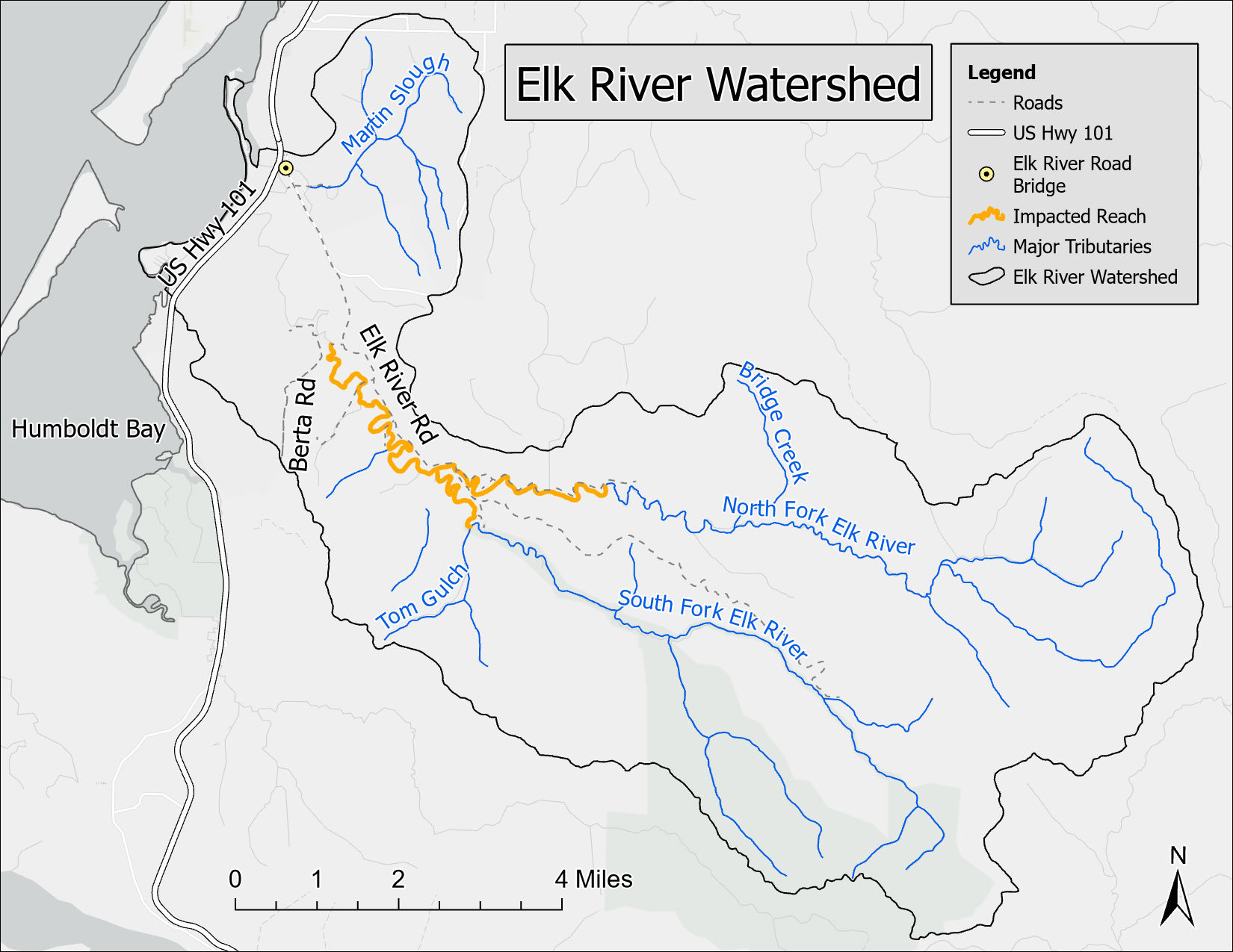
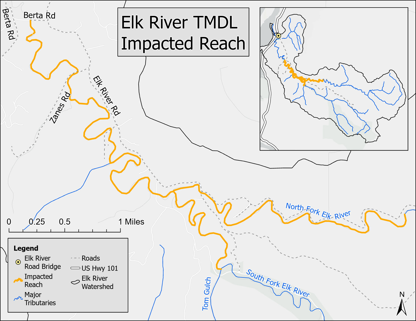
The Regional Water Board received funding in 2013 from the State Water Resources Control Board's Cleanup and Abatement Account to conduct the Elk River Recovery Assessment to Restore Beneficial Uses and Abate Nuisance Flooding Conditions (Recovery Assessment) and conduct a Sediment Remediation Pilot Project (Pilot Project). The Recovery Assessment was designed to assess the fate and transport of fine sediment in the middle and lower reaches of the Elk River from the top of the depositional reach (upstream of the confluence of the North and South Forks) downstream to Humboldt Bay, commonly known as the Impacted Reach. The Recovery Assessment required the collection of sediment and hydraulic data which was used to populate a hydrodynamic and sediment transport model, which was used to evaluate the effects of three different management scenarios – existing conditions, reduced sediment loads, and a modified channel.
The Pilot Project involved the mechanical removal of road base fill and the elevated approach to the Steel Bridge, which has served as an impediment to flood flows in the impacted reach. Modifying this feature has the potential to contribute to the improvement of floodplain hydrodynamics in this reach. This project was successfully completed (with funds from the State Coastal Conservancy) in the Fall of 2017.
The end product of the Recovery Assessment is represented by the Elk River Recovery Assessment: Recovery Framework, completed in December 2018.
- Overview of Regional Water Board Programs in Elk River
- RCAA Water Board Grant Overview
- A Restoration Approach for Elk River
- Elk River Pilot Modeling
- Elk River Pilot Project Hydrodynamic and Sediment Transport Model
2012
Elk River Restoration Summit
On February 8 and 9, 2012, staff of the Regional Water Board, in coordination with Redwood Community Action Agency (RCAA) held a public workshop to explore strategies for restoration of the low gradient reaches of Elk River impacted by stored sediment deposits. The primary purpose of this summit was to convene affected landowners, resource agency staff, technical experts, potential funders, and diverse stakeholders to discuss approaches to addressing long-standing channel restoration, excess sediment loads, nuisance flooding, and related issues in the Lower Elk River watershed.
Presentations from the summit include:
March 15, 2012 Public Workshop
On March 15, 2012 the Regional Water Board held a public workshop on the development of the Sediment TMDL in the Elk River watershed. The purpose of the workshop was to inform the Regional Water Board and public about the status of the Elk River TMDL, discuss related actions that are an outgrowth of the TMDL development, and present a schedule for completion of the draft TMDL and associated Basin Plan amendment. The following links are for materials associated with the workshop:
- CEQA Glossary (pdf, 114 Kb)
- Environmental Checklist Form (pdf, 58 Kb)
- Summary of CEQA Scoping Comments (pdf, 36 Kb)
- Draft Chapter 1 Elk River TMDL Introduction (pdf, 5 Mb)
- Draft Chapter 2 Elk River TMDL Problem Statement (pdf, 5 Mb)
- Appendix A Elk River and Freshwater Creek TMDL Resident Interviews (pdf, 3 Mb)
- Appendix B LiDAR Report (pdf, 374 Kb)
- Appendix C History of Regional Water Board Regulatory Actions in Elk River (pdf, 37 Kb)
- Appendix D Tributary Fisheries Summaries (pdf, 29 Kb)
- Draft Chapter 3 Upper Elk River Source Analysis (May, 2011) (pdf, 1.5 Mb)
- Information Sheet for the Draft Sediment Source Inventory for the Upper Elk River (pdf, 26 Kb)
- Draft Elk River TMDL Implementation Framework (pdf, 176 Kb)
2009
CEQA Resources:
CEQA Scoping:
On April 17, 2009, Regional Water Board staff announced the start of the required California Environmental Quality Act (CEQA) scoping period for the Elk River Sediment TMDL. On May 20, 2009, Regional Water Board staff held a CEQA scoping meeting in Eureka. The purpose of the CEQA scoping meeting was to describe the Regional Water Board staff's approach for development of the Elk River Sediment TMDL. Staff provided examples of best management practices (BMPs) that might reasonably be implemented to comply with the sediment TMDL and to seek the public's input on potential environmental impacts that might result from construction and maintenance of this type of BMPs. The scoping period remained open until June 22, 2009, during which the public was invited to submit additional comments. A summary of the written CEQA Scoping Comments received by Regional Water Board staff are provided below.
CEQA Scoping Documents
- Elk River TMDL Area (12/13/2007, pdf, 227 Kb)
- Freshwater Creek TMDL Sediment Source Assessment, Phase 1 (8/2006)
- Preliminary Assessment Of Flooding In Lower Elk River (8/17/2004)
- The Independent Scientific Review Panel's Final Report on Sediment Impairment and Effects on Beneficial Uses of the Elk River and Stitz, Bear, Jordan and Freshwater Creeks (12/27/2002)
- The Independent Scientific Review Panel's Phase II of the Final Report on Sediment Impairment and Effects on Beneficial Uses of the Elk River and Stitz, Bear, Jordan and Freshwater Creeks is now available (8/12/2003)
- Staff Report for Proposed Regional Water Board Actions in the North Fork Elk River, Bear Creek, Freshwater Creek, Jordan Creek and Stitz Creek Watersheds (9/9/2000)
Other Available Documents 2000-2007
Mailing Lists
Join the Region 1 Email List to receive notifications from the North Coast Regional Water Quality Control Board.
Contact Us
- Elizabeth Pope, Senior Environmental Scientist-Humboldt Bay Watershed Steward
707-445-6131
Elizabeth.Pope@waterboards.ca.gov
Understanding TMDLs
Elk River TMDL Documents
North Coast Region TMDL Projects
- Albion River
- Big River
- Coastal Pathogens
- Eel River, North Fork
- Eel River, Upper Main
- Eel River, Middle Main
- Eel River, Middle Fork
- Eel River, Lower Main
- Eel River, South Fork
- Elk River
- Freshwater Creek
- Garcia River
- Gualala River
- Klamath River
- Laguna De Santa Rosa
- Lost River, Upper
- Lost River, Lower
- Mad River
- Mattole River
- Navarro River
- Noyo River
- Redwood Creek
- Russian River
- Salmon River
- Scott River
- Shasta River
- Stemple Creek
- Ten Mile River
- Trinity River
- Trinity River, South Fork
- Van Duzen River
(Page last updated 3/15/24)
Water is a precious resource in California, and maintaining its quality is of utmost importance to safeguard the health of the public and the environment.
Statewide Campaigns
EPA Water Sense
File an Environmental Complaint
Save Our Water
Flex Alert
Register to Vote
