| Water Body Name: | Pinto Lake |
| Water Body ID: | CAL3051003020020124122807 |
| Water Body Type: | Lake & Reservoir |
Lines of Evidence (LOEs) for Decision ID 14371 |
| LOE ID: | 15331 |
| Pollutant: | Chloride |
| LOE Subgroup: | Pollutant-Water |
| Matrix: | Water |
| Fraction: | None |
| Beneficial Use: | Agricultural Supply |
| Number of Samples: | 133 |
| Number of Exceedances: | 0 |
| Data and Information Type: | PHYSICAL/CHEMICAL MONITORING |
| Data Used to Assess Water Quality: | Central Coast Regional Board Staff assessed City of Watsonville Monitoring at Pinto Lake (PintoLake) data for Pinto Lake to determine beneficial use support and results are as follows: 0 of 133 samples exceed the criterion for Chloride. |
| Data Reference: | Photo showing algae #1 |
| Photo showing algae #2 | |
| Photo showing algae #3 | |
| Site Map - Pinto Lake aerial | |
| Final Data File used for assessment: Multiple data sets, City of Santa Maria, Watsonville and Santa Barbara Channel Keeper Data | |
| Water Quality Objective/Criterion: | Waters shall not contain concentrations of chemical constituents in amounts which adversely affect the agricultural beneficial use. Interpretation of adverse effect shall be as derived from the University of California Agricultural Extension Service guidelines provided in Table 3-3 (Central Coast Waterboard Basin Plan, Chapter III, Section II.A.2 Objectives for all Inland and Surface Waters, Enclosed Bays and Estuaries). In Table 3-3 of the Basin Plan (page III-8), water quality guidelines state that severe problems may occur when chloride exceeds 106 mg/L in irrigation supply water. |
| Objective/Criterion Reference: | Water Quality Control Plan Central Coast Region (R3) Basin Plan |
| Evaluation Guideline: | |
| Guideline Reference: | |
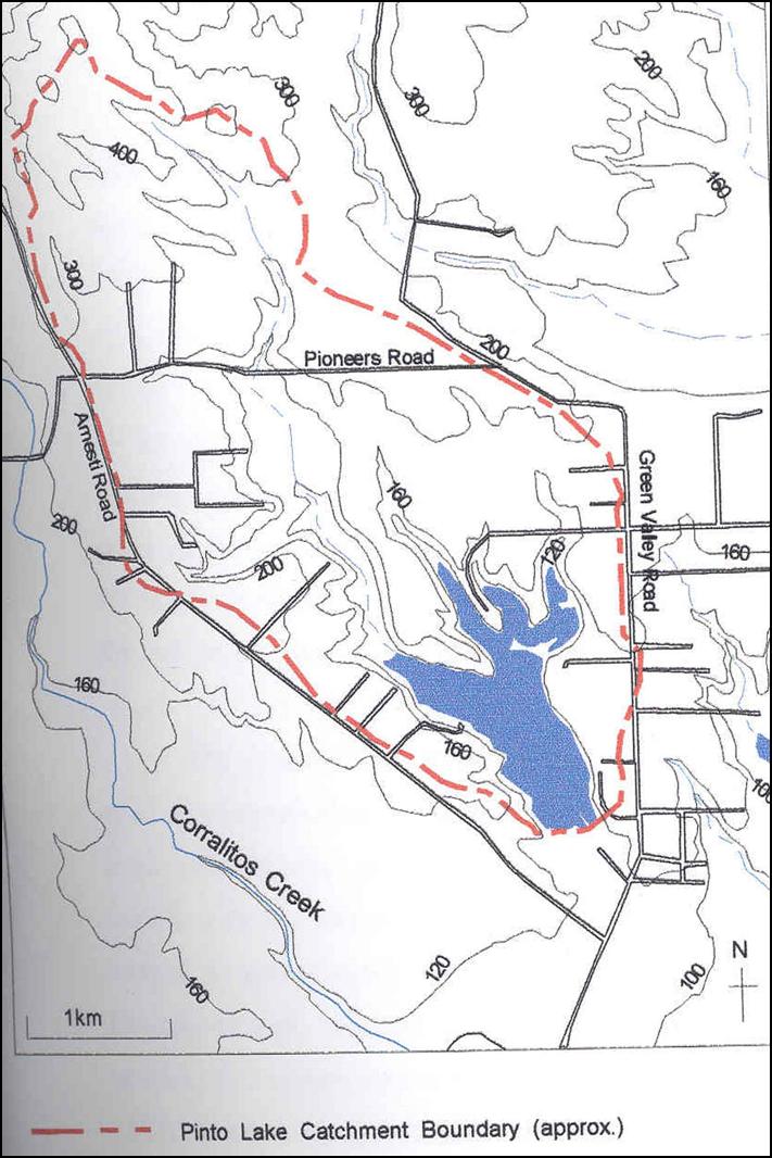
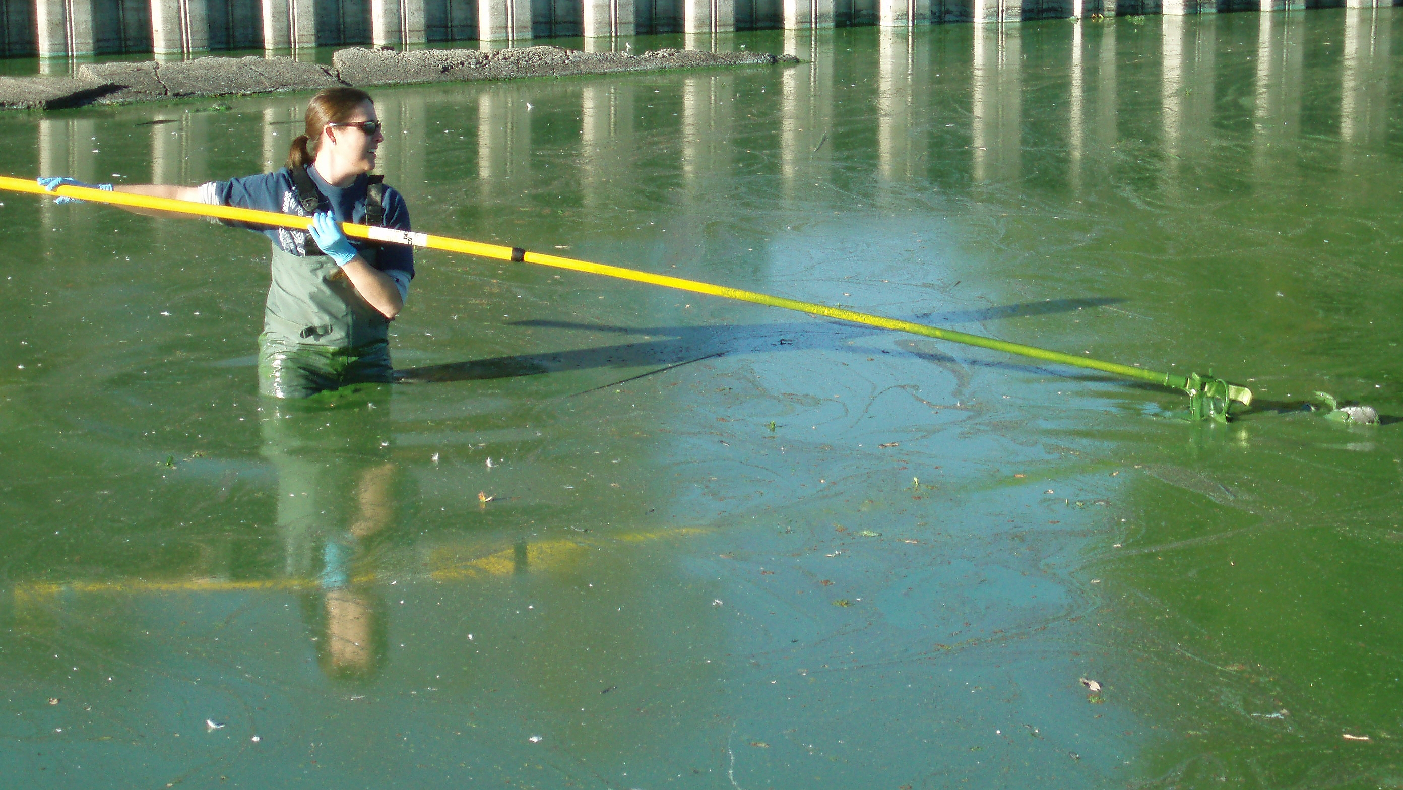
| Spatial Representation: | Data for this line of evidence for Pinto Lake was collected at 9 monitoring sites [ 305PNTO3s - Pinto Lake - South near docks - surface, 305PNTO1m - Pinto Lake - West Arm - mid water column depth, 305PNTO1b - Pinto Lake - West Arm - bottom depth, 305PNTO1s - Pinto Lake - West Arm - surface depth, 305PNTO2b - Pinto Lake - Center - bottom depth, 305PNTO2s - Pinto Lake - Center - surface depth, 305PNTO2m - Pinto Lake - Center - mid water column depth, 305PNTO3m - Pinto Lake - South near docks - middle of water column, 305PNTO3b - Pinto Lake - South near docks - bottom] |
| Temporal Representation: | Data was collected over the time period 6/10/2005-5/22/2006. City of Watsonville monitoring at Pinto Lake was conducted monthly. |
| Environmental Conditions: | Staff is not aware of any special conditions that might effect interpretation of the data. |
| QAPP Information: | Grab samples are analyzed at a ELAP certified laboratory and follows the laboratory QAPP. |
| QAPP Information Reference(s): | e-mail stating no QAPP but all analysis is conducted at ELAP certified laboratory |
Lines of Evidence (LOEs) for Decision ID 14373 |
| LOE ID: | 15332 |
| Pollutant: | Electrical Conductivity |
| LOE Subgroup: | Pollutant-Water |
| Matrix: | Water |
| Fraction: | None |
| Beneficial Use: | Agricultural Supply |
| Number of Samples: | 132 |
| Number of Exceedances: | 0 |
| Data and Information Type: | PHYSICAL/CHEMICAL MONITORING |
| Data Used to Assess Water Quality: | Central Coast Regional Board Staff assessed City of Watsonville Monitoring at Pinto Lake (PintoLake) data for Pinto Lake to determine beneficial use support and results are as follows: 0 of 132 samples exceed the criterion for Conductivity(Us). |
| Data Reference: | Photo showing algae #1 |
| Photo showing algae #2 | |
| Photo showing algae #3 | |
| Site Map - Pinto Lake aerial | |
| Final Data File used for assessment: Multiple data sets, City of Santa Maria, Watsonville and Santa Barbara Channel Keeper Data | |
| Water Quality Objective/Criterion: | Waters shall not contain concentrations of chemical constituents in amounts which adversely affect the agricultural beneficial use. Interpretation of adverse effect shall be as derived from the University of California Agricultural Extension Service guidelines provided in Table 3-3 (Central Coast Waterboard Basin Plan, Chapter III, Section II.A.2 Objectives for all Inland and Surface Waters, Enclosed Bays and Estuaries). In Table 3-3 of the Basin Plan (page III-8), water quality guidelines state that severe problems may occur when conductivity exceeds 3.0 mS/cm in irrigation supply water. |
| Objective/Criterion Reference: | Water Quality Control Plan Central Coast Region (R3) Basin Plan |
| Evaluation Guideline: | |
| Guideline Reference: | |
| Spatial Representation: | Data for this line of evidence for Pinto Lake was collected at 9 monitoring sites [ 305PNTO3s - Pinto Lake - South near docks - surface, 305PNTO1m - Pinto Lake - West Arm - mid water column depth, 305PNTO1b - Pinto Lake - West Arm - bottom depth, 305PNTO1s - Pinto Lake - West Arm - surface depth, 305PNTO2b - Pinto Lake - Center - bottom depth, 305PNTO2s - Pinto Lake - Center - surface depth, 305PNTO2m - Pinto Lake - Center - mid water column depth, 305PNTO3m - Pinto Lake - South near docks - middle of water column, 305PNTO3b - Pinto Lake - South near docks - bottom] |
| Temporal Representation: | Data was collected over the time period 6/10/2005-5/22/2006. City of Watsonville monitoring at Pinto Lake was conducted monthly. |
| Environmental Conditions: | Staff is not aware of any special conditions that might effect interpretation of the data. |
| QAPP Information: | Grab samples are analyzed at a ELAP certified laboratory and follows the laboratory QAPP. |
| QAPP Information Reference(s): | e-mail stating no QAPP but all analysis is conducted at ELAP certified laboratory |
Lines of Evidence (LOEs) for Decision ID 14374 |
| LOE ID: | 15041 |
| Pollutant: | Nitrate |
| LOE Subgroup: | Pollutant-Water |
| Matrix: | Water |
| Fraction: | None |
| Beneficial Use: | Agricultural Supply |
| Number of Samples: | 133 |
| Number of Exceedances: | 0 |
| Data and Information Type: | PHYSICAL/CHEMICAL MONITORING |
| Data Used to Assess Water Quality: | Central Coast Regional Board Staff assessed City of Watsonville Monitoring at Pinto Lake (PintoLake) data for Pinto Lake to determine beneficial use support and results are as follows: 0 of 133 samples exceed the criterion for Nitrate as N. |
| Data Reference: | Photo showing algae #1 |
| Photo showing algae #2 | |
| Photo showing algae #3 | |
| Site Map - Pinto Lake aerial | |
| Final Data File used for assessment: Multiple data sets, City of Santa Maria, Watsonville and Santa Barbara Channel Keeper Data | |
| Water Quality Objective/Criterion: | Waters shall not contain concentrations of chemical constituents in amounts which adversely affect the agricultural beneficial use. Interpretation of adverse effect shall be as derived from the University of California Agricultural Extension Service guidelines provided in Table 3-3 (Central Coast Waterboard Basin Plan, Chapter III, Section II.A.2 Objectives for all Inland and Surface Waters, Enclosed Bays and Estuaries). In Table 3-3 of the Basin Plan (page III-8), water quality guidelines state that severe problems may occur when nitrate exceeds 30 mg/L NO3 as N in irrigation supply water. |
| Objective/Criterion Reference: | Water Quality Control Plan Central Coast Region (R3) Basin Plan |
| Evaluation Guideline: | |
| Guideline Reference: | |
| Spatial Representation: | Data for this line of evidence for Pinto Lake was collected at 9 monitoring sites [ 305PNTO3s - Pinto Lake - South near docks - surface, 305PNTO1m - Pinto Lake - West Arm - mid water column depth, 305PNTO1b - Pinto Lake - West Arm - bottom depth, 305PNTO1s - Pinto Lake - West Arm - surface depth, 305PNTO2b - Pinto Lake - Center - bottom depth, 305PNTO2s - Pinto Lake - Center - surface depth, 305PNTO2m - Pinto Lake - Center - mid water column depth, 305PNTO3m - Pinto Lake - South near docks - middle of water column, 305PNTO3b - Pinto Lake - South near docks - bottom] |
| Temporal Representation: | Data was collected over the time period 6/10/2005-5/22/2006. City of Watsonville monitoring at Pinto Lake was conducted monthly. |
| Environmental Conditions: | Staff is not aware of any special conditions that might effect interpretation of the data. |
| QAPP Information: | Grab samples are analyzed at a ELAP certified laboratory and follows the laboratory QAPP. |
| QAPP Information Reference(s): | e-mail stating no QAPP but all analysis is conducted at ELAP certified laboratory |
| | |
| LOE ID: | 15042 |
| Pollutant: | Nitrate |
| LOE Subgroup: | Pollutant-Water |
| Matrix: | Water |
| Fraction: | None |
| Beneficial Use: | Municipal & Domestic Supply |
| Number of Samples: | 133 |
| Number of Exceedances: | 0 |
| Data and Information Type: | PHYSICAL/CHEMICAL MONITORING |
| Data Used to Assess Water Quality: | Central Coast Regional Board Staff assessed City of Watsonville Monitoring at Pinto Lake (PintoLake) data for Pinto Lake to determine beneficial use support and results are as follows: 0 of 133 samples exceed the criterion for Nitrate as N. |
| Data Reference: | Photo showing algae #1 |
| Photo showing algae #2 | |
| Photo showing algae #3 | |
| Site Map - Pinto Lake aerial | |
| Final Data File used for assessment: Multiple data sets, City of Santa Maria, Watsonville and Santa Barbara Channel Keeper Data | |
| Water Quality Objective/Criterion: | The Water Quality Control Plan, Central Coast Basin Objective for municipal and domestic supply uses of inland surface waters (Section II.A.2) states the following: waters shall not contain concentrations of chemical constituents in excess of the limits specified in California Code of Regulations, Title 22, Article 4, Chapter 15, Section 64435, Tables 2 and 3 as listed in Table 3-2. The maximum contaminant level listed in Table 3-2 (inorganic and fluoride concentrations not to be exceeded in domestic or municipal supply) for nitrate is 10.0 mg/L (NO3 as N). |
| Objective/Criterion Reference: | Title 22, Division 4, Ch. 15, Article 4, Section 64431, Table 64431-A |
| Water Quality Control Plan Central Coast Region (R3) Basin Plan | |
| Evaluation Guideline: | |
| Guideline Reference: | |
| Spatial Representation: | Data for this line of evidence for Pinto Lake was collected at 9 monitoring sites [ 305PNTO3s - Pinto Lake - South near docks - surface, 305PNTO1m - Pinto Lake - West Arm - mid water column depth, 305PNTO1b - Pinto Lake - West Arm - bottom depth, 305PNTO1s - Pinto Lake - West Arm - surface depth, 305PNTO2b - Pinto Lake - Center - bottom depth, 305PNTO2s - Pinto Lake - Center - surface depth, 305PNTO2m - Pinto Lake - Center - mid water column depth, 305PNTO3m - Pinto Lake - South near docks - middle of water column, 305PNTO3b - Pinto Lake - South near docks - bottom] |
| Temporal Representation: | Data was collected over the time period 6/10/2005-5/22/2006. City of Watsonville monitoring at Pinto Lake was conducted monthly. |
| Environmental Conditions: | Staff is not aware of any special conditions that might effect interpretation of the data. |
| QAPP Information: | Grab samples are analyzed at a ELAP certified laboratory and follows the laboratory QAPP. |
| QAPP Information Reference(s): | e-mail stating no QAPP but all analysis is conducted at ELAP certified laboratory |
Lines of Evidence (LOEs) for Decision ID 14370 |
| LOE ID: | 15024 |
| Pollutant: | Ammonia as Nitrogen |
| LOE Subgroup: | Pollutant-Water |
| Matrix: | Water |
| Fraction: | None |
| Beneficial Use: | Municipal & Domestic Supply |
| Number of Samples: | 133 |
| Number of Exceedances: | 0 |
| Data and Information Type: | PHYSICAL/CHEMICAL MONITORING |
| Data Used to Assess Water Quality: | Central Coast Regional Board Staff assessed City of Watsonville Monitoring at Pinto Lake (PintoLake) data for Pinto Lake to determine beneficial use support and results are as follows: 0 of 133 samples exceed the criterion for Ammonia as N, Total. |
| Data Reference: | Photo showing algae #1 |
| Photo showing algae #2 | |
| Photo showing algae #3 | |
| Site Map - Pinto Lake aerial | |
| Final Data File used for assessment: Multiple data sets, City of Santa Maria, Watsonville and Santa Barbara Channel Keeper Data | |
| Water Quality Objective/Criterion: | USEPA Health Advisory 2006 Edition of the Drinking Water Standards and Health Advisories (EPA 822-R-06-013, 2006). |
| Objective/Criterion Reference: | 2006 edition of the drinking water standards and health advisories. EPA 822-R-03-013 |
| Evaluation Guideline: | EPA's Lifetime Health advisory level for total ammonia is 30.0 mg/L as stated on page 8 of the 2006 edition of the drinking water standards and health advisories. This Advisory Level is defined as "the concentration of a chemical in drinking water that is not expected to cause any adverse noncarcinogenic effects for up to ten days of exposure." |
| Guideline Reference: | 2006 edition of the drinking water standards and health advisories. EPA 822-R-03-013 |
| Spatial Representation: | Data for this line of evidence for Pinto Lake was collected at 9 monitoring sites [ 305PNTO3s - Pinto Lake - South near docks - surface, 305PNTO1m - Pinto Lake - West Arm - mid water column depth, 305PNTO1b - Pinto Lake - West Arm - bottom depth, 305PNTO1s - Pinto Lake - West Arm - surface depth, 305PNTO2b - Pinto Lake - Center - bottom depth, 305PNTO2s - Pinto Lake - Center - surface depth, 305PNTO2m - Pinto Lake - Center - mid water column depth, 305PNTO3m - Pinto Lake - South near docks - middle of water column, 305PNTO3b - Pinto Lake - South near docks - bottom] |
| Temporal Representation: | Data was collected over the time period 6/10/2005-5/22/2006. City of Watsonville monitoring at Pinto Lake was conducted monthly. |
| Environmental Conditions: | Staff is not aware of any special conditions that might effect interpretation of the data. |
| QAPP Information: | Grab samples are analyzed at a ELAP certified laboratory and follows the laboratory QAPP. |
| QAPP Information Reference(s): | e-mail stating no QAPP but all analysis is conducted at ELAP certified laboratory |
Lines of Evidence (LOEs) for Decision ID 14376 |
| LOE ID: | 14952 |
| Pollutant: | Turbidity |
| LOE Subgroup: | Pollutant-Water |
| Matrix: | Water |
| Fraction: | None |
| Beneficial Use: | Warm Freshwater Habitat |
| Aquatic Life Use: | Warm Freshwater Habitat |
| Number of Samples: | 131 |
| Number of Exceedances: | 27 |
| Data and Information Type: | PHYSICAL/CHEMICAL MONITORING |
| Data Used to Assess Water Quality: | Central Coast Regional Board Staff assessed City of Watsonville Monitoring at Pinto Lake (PintoLake) data for Pinto Lake to determine beneficial use support and results are as follows: 27 of 131 samples exceed the criterion for Turbidity(NTU). |
| Data Reference: | Photo showing algae #1 |
| Photo showing algae #2 | |
| Photo showing algae #3 | |
| Site Map - Pinto Lake aerial | |
| Final Data File used for assessment: Multiple data sets, City of Santa Maria, Watsonville and Santa Barbara Channel Keeper Data | |
| Water Quality Objective/Criterion: | Waters shall be free of changes in turbidity that cause nuisance or adversely affect beneficial uses. Water Quality Control Plan, Central Coast Basin, Chapter III, Section II.A.2 Objectives for all Inland Surface Waters, Enclosed Bays and Estuaries. |
| Objective/Criterion Reference: | Water Quality Control Plan Central Coast Region (R3) Basin Plan |
| Evaluation Guideline: | Sigler et al. (1984) states that turbidities of 25 NTU's or greater caused reduction in juvenile salmonid growth due to interference with their ability to find food. |
| Guideline Reference: | Effects of chronic turbidity on density and growth of steelheads and coho salmon. Transactions of the American Fisheries Society 113:142-150 |
| Spatial Representation: | Data for this line of evidence for Pinto Lake was collected at 9 monitoring sites [ 305PNTO3s - Pinto Lake - South near docks - surface, 305PNTO1m - Pinto Lake - West Arm - mid water column depth, 305PNTO1b - Pinto Lake - West Arm - bottom depth, 305PNTO1s - Pinto Lake - West Arm - surface depth, 305PNTO2b - Pinto Lake - Center - bottom depth, 305PNTO2s - Pinto Lake - Center - surface depth, 305PNTO2m - Pinto Lake - Center - mid water column depth, 305PNTO3m - Pinto Lake - South near docks - middle of water column, 305PNTO3b - Pinto Lake - South near docks - bottom] |
| Temporal Representation: | Data was collected over the time period 6/10/2005-5/22/2006. City of Watsonville monitoring at Pinto Lake was conducted monthly. |
| Environmental Conditions: | Staff is not aware of any special conditions that might effect interpretation of the data. |
| QAPP Information: | Grab samples are analyzed at a ELAP certified laboratory and follows the laboratory QAPP. |
| QAPP Information Reference(s): | e-mail stating no QAPP but all analysis is conducted at ELAP certified laboratory |
Lines of Evidence (LOEs) for Decision ID 14372 |
| LOE ID: | 15330 |
| Pollutant: | Chlorophyll-a |
| LOE Subgroup: | Pollutant-Water |
| Matrix: | Water |
| Fraction: | None |
| Beneficial Use: | Warm Freshwater Habitat |
| Aquatic Life Use: | Warm Freshwater Habitat |
| Number of Samples: | 61 |
| Number of Exceedances: | 27 |
| Data and Information Type: | PHYSICAL/CHEMICAL MONITORING |
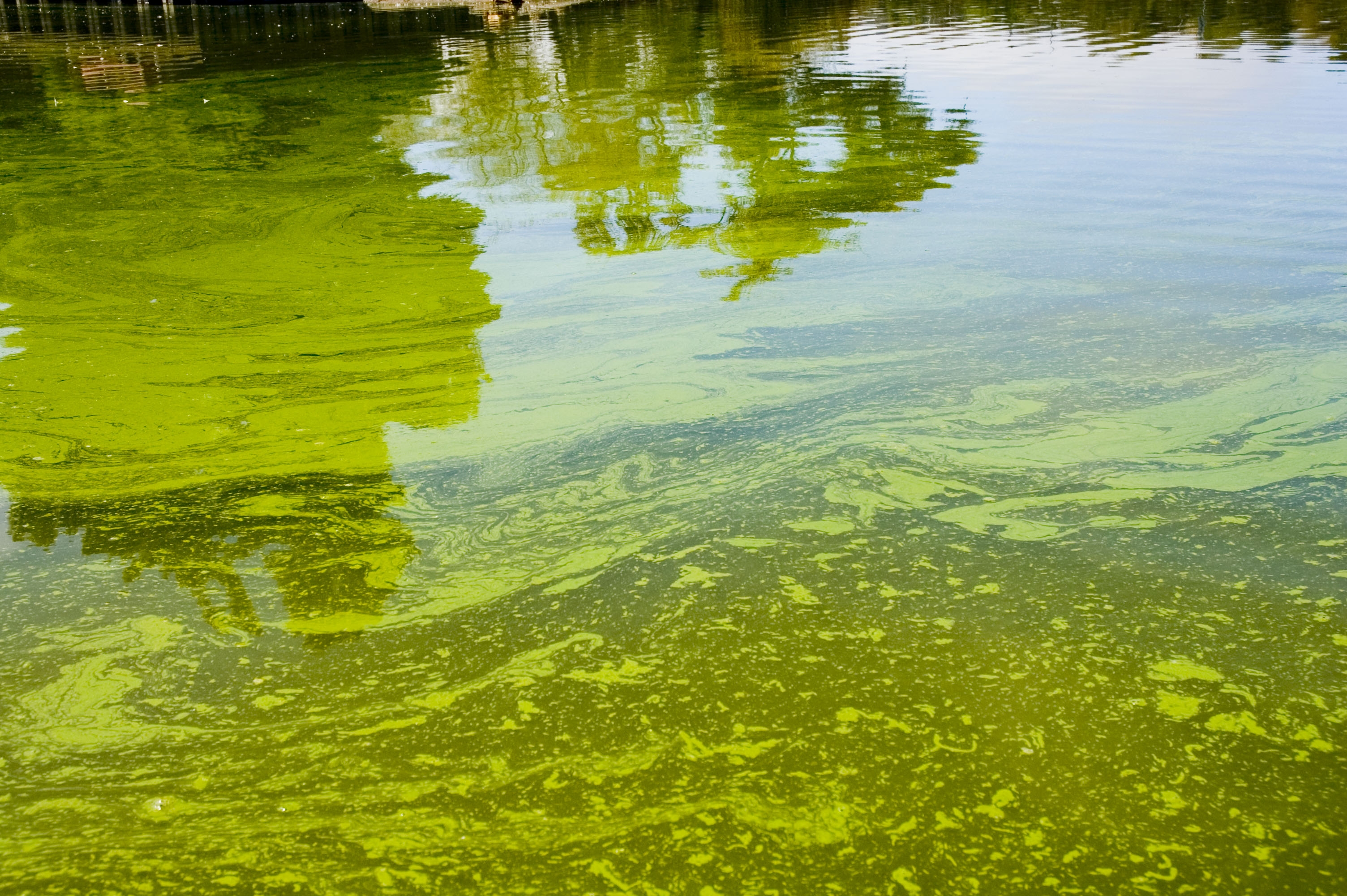
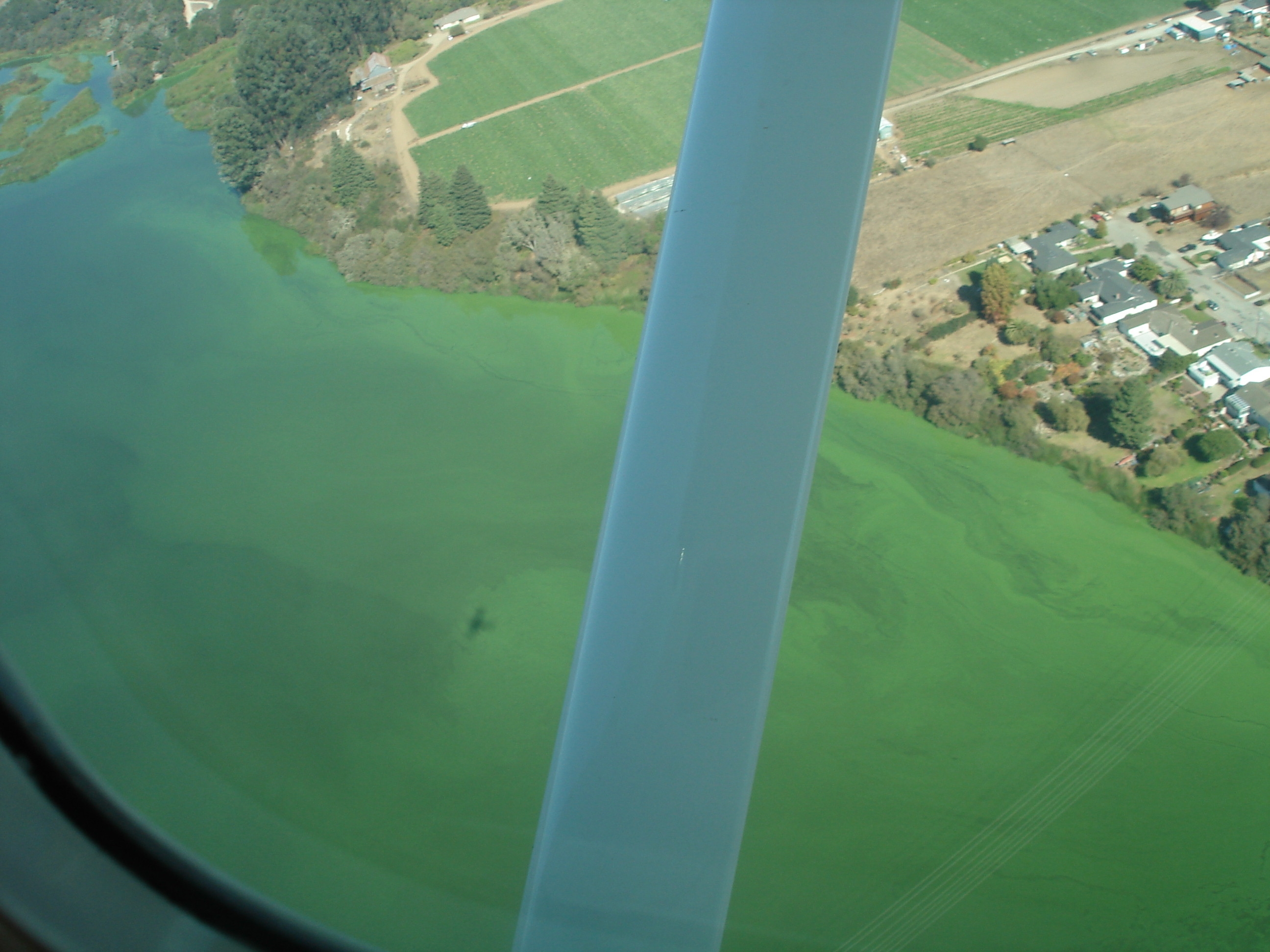
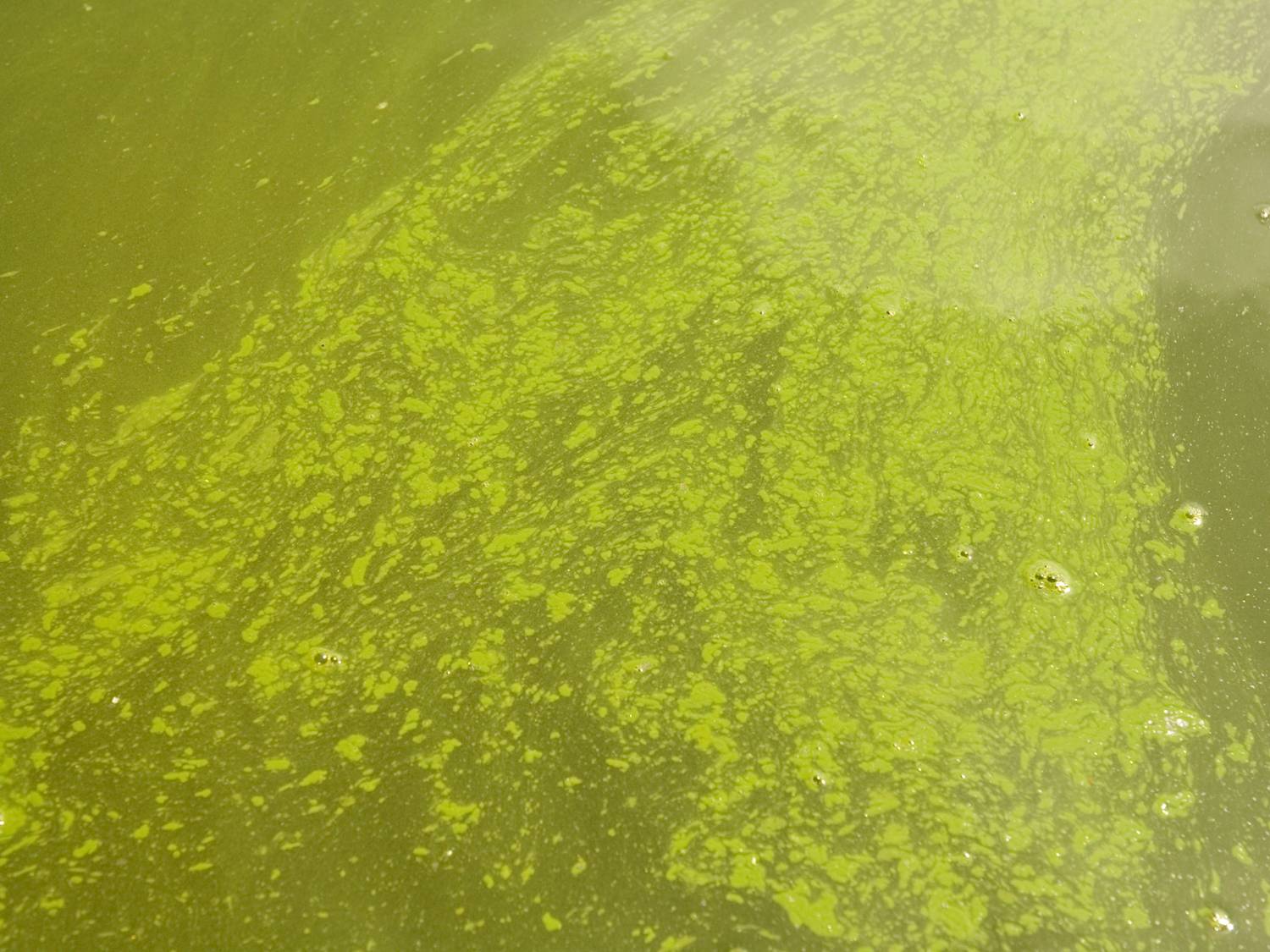
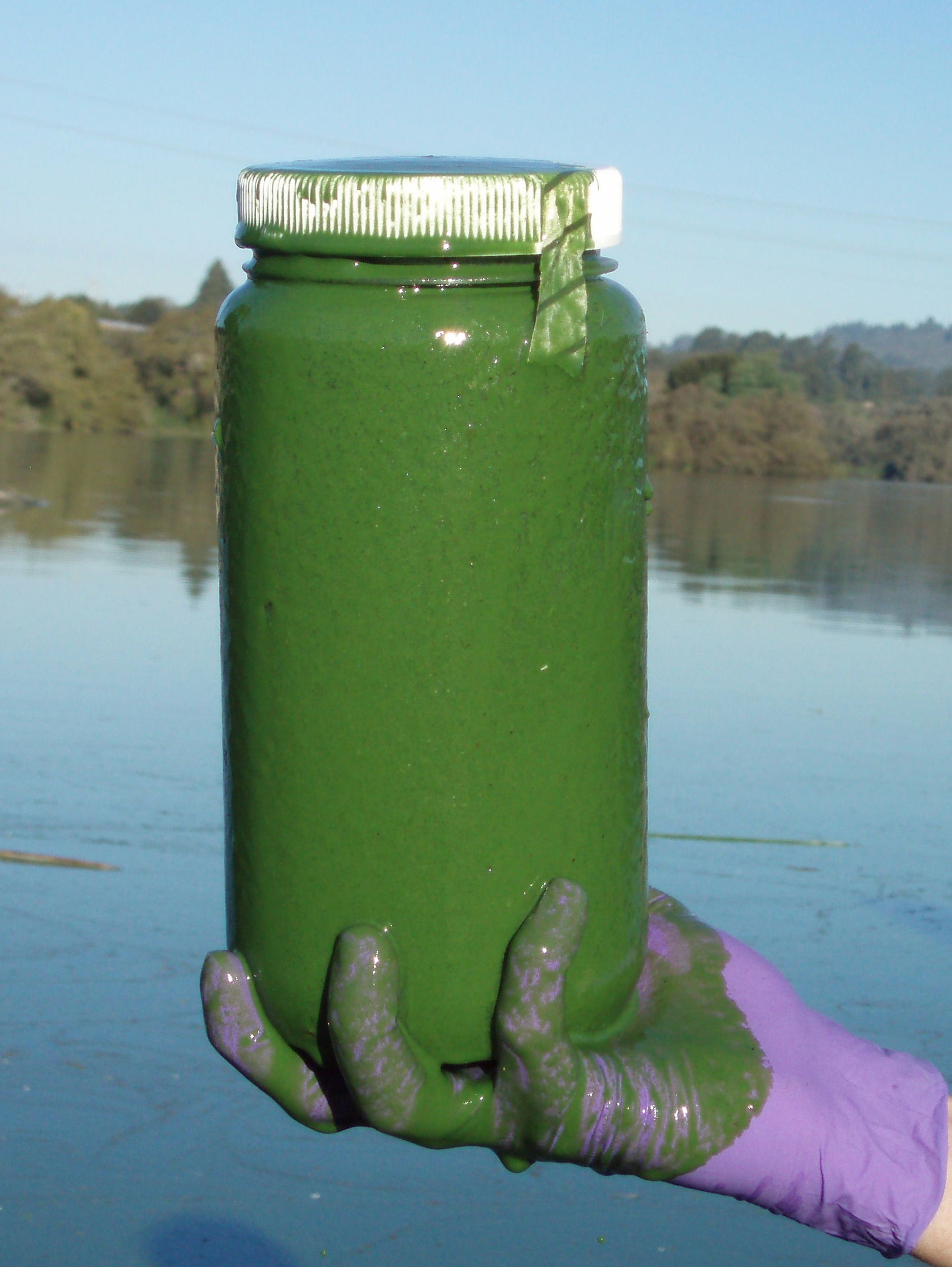
| Data Used to Assess Water Quality: | Central Coast Regional Board Staff assessed City of Watsonville Monitoring at Pinto Lake (PintoLake) data for Pinto Lake to determine beneficial use support and results are as follows: 27 of 61 samples exceed the criterion for Chlorophyll a. In addition, three photos are available in the administrative record and show algal blooms in Pinto Lake. |
| Data Reference: | Aerial photo showing algal bloom in Pinto lake |
| Photo showing algae #1 | |
| Photo showing algae #2 | |
| Photo showing algae #3 | |
| Presentation slides showing Microcystin data from Pinto Lake and other California waters. | |
| Site Map - Pinto Lake aerial | |
| Final Data File used for assessment: Multiple data sets, City of Santa Maria, Watsonville and Santa Barbara Channel Keeper Data | |
| Water Quality Objective/Criterion: | Waters shall not contain biostimulatory substances in concentrations that promote aquatic growths to the extent that such growths cause nuisance or adversely affect beneficial uses (general objective for biostimulatory substances, Water Quality Control Plan, Central Coast Basin, Chapter III, Section II). |
| Objective/Criterion Reference: | Water Quality Control Plan Central Coast Region (R3) Basin Plan |
| North Carolina standards, criteria, or toxic concentrations. Adopted per title 15A North Carolina Administrative Code subchapter 2B - Surface water and wetland standards | |
| Water quality standards table | |
| Evaluation Guideline: | North Carolina Administrative code (NCAC), Title 15A Environmental and Natural Resources, Subchapter 2B-Surface water and wetland standards, Rule 0211-Fresh surface water quality standards for class C waters (Class C is defined as freshwaters protected for secondary recreation, fishing, aquatic life including propagation and survival, and wildlife). Section 3(a) of Rule 0211 applies to all fresh surface waters and states that chlorophyll a is not to exceed 40 ug/L. |
| Guideline Reference: | North Carolina standards, criteria, or toxic concentrations. Adopted per title 15A North Carolina Administrative Code subchapter 2B - Surface water and wetland standards |
| North Carolina standards, criteria, or toxic concentrations. Adopted per title 15A North Carolina Administrative Code subchapter 2B - Surface water and wetland standards | |
| Spatial Representation: | Data for this line of evidence for Pinto Lake was collected at 3 monitoring sites [ 305PNTO3s - Pinto Lake - South near docks, 305PNTO1s - Pinto Lake - West Arm, 305PNTO2s - Pinto Lake - Center] |
| Temporal Representation: | Data was collected over the time period 6/10/2005-5/22/2006. City of Watsonville monitoring at Pinto Lake was conducted monthly. |
| Environmental Conditions: | Staff is not aware of any special conditions that might effect interpretation of the data. |
| QAPP Information: | Grab samples are analyzed at a ELAP certified laboratory and follows the laboratory QAPP. |
| QAPP Information Reference(s): | e-mail stating no QAPP but all analysis is conducted at ELAP certified laboratory |
| | |
| LOE ID: | 27027 |
| Pollutant: | Chlorophyll-a |
| LOE Subgroup: | Pollutant-Water |
| Matrix: | Water |
| Fraction: | None |
| Beneficial Use: | Water Contact Recreation |
| Number of Samples: | 61 |
| Number of Exceedances: | 22 |
| Data and Information Type: | PHYSICAL/CHEMICAL MONITORING |
| Data Used to Assess Water Quality: | Central Coast Waterboard Staff assessed chlorophyll a data collected from a three monitoring sites in Pinto Lake (305PINTO1, 305PINTO2 and 305PINTO1) to determine beneficial use support. These three sites are spatially independent and are located more than 200m apart. In addition to chlorophyll a analysis City of Watsonville staff also identified algal species present and made note of the relative density of these algae in each sample. The WHO guideline for chlorophyll a levels at which there is a moderate probability of adverse health effects (e.g. skin irritations and gastrointestinal illness) is 50 ug/L and having a dominance of cyanobacteria. The WHO guidelines also state the following genera are among the most common toxic cyanobacteria in freshwater: Microcystis, Anabaena and Aphanizomenon. Chlorophyll a samples were collected monthly from each of the three sites in the lake between June 2005 and May 2006. Of these, 22 of 61 chlorophyll a samples results exceeded 50 ug/L. In all but two samples exceeding the guideline value, one or more of the above listed cyanobacteria genera were dominate in the sample. |
| Data Reference: | Final Data File used for assessment: Multiple data sets, City of Santa Maria, Watsonville and Santa Barbara Channel Keeper Data |
| Water Quality Objective/Criterion: | Water Quality Control Plan, Central Coast Basin General Objective for all inland surface waters states that waters shall not contain biostimulatory substances in concentrations that promote aquatic growths to the extent that such growths cause nuisance or adversely affect beneficial uses (Water Quality Control Plan, Central Coast Basin, General Objective Chapter III, Section II.A.2 Objectives for all Inland Surface Waters, Enclosed Bays and Estuaries). |
| Objective/Criterion Reference: | Water Quality Control Plan Central Coast Region (R3) Basin Plan |
| Final Data File used for assessment: Multiple data sets, City of Santa Maria, Watsonville and Santa Barbara Channel Keeper Data | |
| Evaluation Guideline: | The WHO guideline for chlorophyll a levels at which there is a moderate probability of adverse health effects (e.g. skin irritations and gastrointestinal illness) is 50 ug/L and having a dominance of cyanobacteria. |
| Guideline Reference: | Guidelines for sage recreational water environments. Chapter 8: Algae and cyanobacteria in freshwater. |
| Toxic Cyanobacteria in Water: A Guide to their Public Health Consequences, Monitoring and Management. World Health Organization. Edited by I. Chorus and J. Bartram. Long, England. 400 pp | |
| Spatial Representation: | Data for this line of evidence was collected from three monitoring sites in Pinto Lake (305PINTO1, 305PINTO2 and 305PINTO1). |
| Temporal Representation: | Data was collected monthly by City of Watsonville Staff between June 2005 and May 2006. |
| Environmental Conditions: | |
| QAPP Information: | Grab samples are analyzed at a ELAP certified laboratory and follows the laboratory QAPP. |
| QAPP Information Reference(s): | |
Lines of Evidence (LOEs) for Decision ID 16203 |
| LOE ID: | 27034 |
| Pollutant: | Cyanobacteria hepatotoxic microcystins |
| LOE Subgroup: | Adverse Biological Responses |
| Matrix: | Water |
| Fraction: | None |
| Beneficial Use: | Wildlife Habitat |
| Number of Samples: | 14 |
| Number of Exceedances: | 10 |
| Data and Information Type: | Not Specified |
| Data Used to Assess Water Quality: | Central Coast Regional Board Staff assessed microcystin toxin data collected from a single monitoring site in Pinto Lake, 305PINTO3s, to determine beneficial use support. Data was collected weekly between 9/28/2006 and 1/10/2007 by City of Watsonville Staff and analyzed at the Citys lab. All fourteen samples contained Microcystis cells. Ten of fourteen samples exceed the criterion for Municipal and Domestic Supply objective as defined by the WHO guidelines (a tolerable daily intake (TDI) guideline value of 1.0 ug/L or ppb). Additional information on the data used for this assessment is below in "Environmental Conditions". |
| Data Reference: | City of Watsonville - Pinto Lake data submittal and correspondence |
| Final Data File used for assessment: Multiple data sets, City of Santa Maria, Watsonville and Santa Barbara Channel Keeper Data | |
| Water Quality Objective/Criterion: | All waters shall be maintained free of toxic substances in concentrations which are toxic to, or which produce detrimental physiological responses in, human, plant, animal, or aquatic life (Water Quality Control Plan, Central Coast Basin, General Objective Chapter III, Section II.A.2 Objectives for all Inland Surface Waters, Enclosed Bays and Estuaries). |
| Objective/Criterion Reference: | Water Quality Control Plan Central Coast Region (R3) Basin Plan |
| Evaluation Guideline: | World Health Organization (WHO) Guidelines for drinking-water quality establishes a tolerable daily intake (TDI) guideline value of 1.0 ug/L for microcystin-LR toxin in drinking water. WHO states this value should be applied to total cell-bound and extracellular microcystins. |
| Guideline Reference: | Guidelines for sage recreational water environments. Chapter 8: Algae and cyanobacteria in freshwater. |
| Toxic Cyanobacteria in Water: A Guide to their Public Health Consequences, Monitoring and Management. World Health Organization. Edited by I. Chorus and J. Bartram. Long, England. 400 pp | |
| Spatial Representation: | Data for this line of evidence was collected from a single sample location (305PINTO3s- Pinto Lake at the boat ramp - sub surface sample). |
| Temporal Representation: | Data was collected weekly by City of Watsonville Staff between 9/28/2006 and 1/10/2007. |
| Environmental Conditions: | Two different analytical test kits were used by City of Watsonville Staff to analyze Microcystin concentration in samples from Pinto Lake. Both Test kits use an Enzyme-Linked ImmunoSorbent Assay (ELISA) to determine microcystin toxin concentration. Samples collected prior to November 8, 2006 were analyzed using Qualitube ET-022, a semi-quantitative method that provides results in three categories (3.0ppb |
| QAPP Information: | Grab samples are analyzed at a ELAP certified laboratory and follows the laboratory QAPP. |
| QAPP Information Reference(s): | |
Lines of Evidence (LOEs) for Decision ID 14375 |
| LOE ID: | 15084 |
| Pollutant: | Oxygen, Dissolved |
| LOE Subgroup: | Pollutant-Water |
| Matrix: | Water |
| Fraction: | Dissolved |
| Beneficial Use: | Warm Freshwater Habitat |
| Aquatic Life Use: | Warm Freshwater Habitat |
| Number of Samples: | 132 |
| Number of Exceedances: | 61 |
| Data and Information Type: | PHYSICAL/CHEMICAL MONITORING |
| Data Used to Assess Water Quality: | Central Coast Regional Board Staff assessed City of Watsonville Monitoring at Pinto Lake (PintoLake) data for Pinto Lake to determine beneficial use support and results are as follows: 61 of 132 samples exceed the criterion for Oxygen, Dissolved. |
| Data Reference: | Photo showing algae #1 |
| Photo showing algae #2 | |
| Photo showing algae #3 | |
| Site Map - Pinto Lake aerial | |
| Final Data File used for assessment: Multiple data sets, City of Santa Maria, Watsonville and Santa Barbara Channel Keeper Data | |
| Water Quality Objective/Criterion: | Water Quality Control Plan, Central Coast Basin, General Objective, Chapter III, Section II.A.2 General Objectives for all Inland Surface Waters, Enclosed Bays and Estuaries states the following: For waters not mentioned by a specific beneficial use, dissolved oxygen concentration shall not be reduced below 5.0 mg/l at any time. |
| Objective/Criterion Reference: | Water Quality Control Plan Central Coast Region (R3) Basin Plan |
| Evaluation Guideline: | |
| Guideline Reference: | |
| Spatial Representation: | Data for this line of evidence for Pinto Lake was collected at 9 monitoring sites [ 305PNTO3s - Pinto Lake - South near docks - surface, 305PNTO1m - Pinto Lake - West Arm - mid water column depth, 305PNTO1b - Pinto Lake - West Arm - bottom depth, 305PNTO1s - Pinto Lake - West Arm - surface depth, 305PNTO2b - Pinto Lake - Center - bottom depth, 305PNTO2s - Pinto Lake - Center - surface depth, 305PNTO2m - Pinto Lake - Center - mid water column depth, 305PNTO3m - Pinto Lake - South near docks - middle of water column, 305PNTO3b - Pinto Lake - South near docks - bottom] |
| Temporal Representation: | Data was collected over the time period 6/10/2005-5/22/2006. City of Watsonville monitoring at Pinto Lake was conducted monthly. |
| Environmental Conditions: | Staff is not aware of any special conditions that might effect interpretation of the data. |
| QAPP Information: | Grab samples are analyzed at a ELAP certified laboratory and follows the laboratory QAPP. |
| QAPP Information Reference(s): | e-mail stating no QAPP but all analysis is conducted at ELAP certified laboratory |
Lines of Evidence (LOEs) for Decision ID 16202 |
| LOE ID: | 27033 |
| Pollutant: | Scum/Foam-unnatural |
| LOE Subgroup: | Pollutant-Water |
| Matrix: | Water |
| Fraction: | None |
| Beneficial Use: | Warm Freshwater Habitat |
| Aquatic Life Use: | Cold Freshwater Habitat | Wildlife Habitat |
| Number of Samples: | 0 |
| Number of Exceedances: | 0 |
| Data and Information Type: | Not Specified |
| Data Used to Assess Water Quality: | Central Coast Waterboard Staff assessed photo documentation of algal blooms in Pinto Lake to determine beneficial use support. The WHO guidelines state that there is a high probability of adverse health effects from cyanobacterial scum formation in areas where whole body contact and or risk of ingestion/aspiration occur. Three photos in the administrative record demonstrate the severity of the algal scum in Pinto Lake in September 2005 and in October 2006. Data provided by the City of Watsonville also show elevated levels of blue green algae (or cyanobacteria) including Microcystis sp and its toxin Microcystin (see LOE #27034). |
| Data Reference: | Aerial photo showing algal bloom in Pinto lake |
| Photo showing algae #1 | |
| Photo showing algae #2 | |
| Photo showing algae #3 | |
| Presentation slides showing Pinto Lake data | |
| Pinto Lake Algae Scum layer photo | |
| Pinto Lake Algae Scum photo 002 | |
| Photo showing staff retrieving a dead bird (American Coot) from Pinto Lake near the launch ramp. | |
| Pinto Lake water sample September 2007 | |
| Water Quality Objective/Criterion: | Water Quality Control Plan, Central Coast Basin General Objective for all inland surface waters states that waters shall not contain floating material, including solids, liquids, foams and scum in concentrations that cause nuisance or adversely affect beneficial uses (Water Quality Control Plan, Central Coast Basin, General Objective Chapter III, Section II.A.2 Objectives for all Inland Surface Waters, Enclosed Bays and Estuaries). |
| Objective/Criterion Reference: | Water Quality Control Plan Central Coast Region (R3) Basin Plan |
| Evaluation Guideline: | The WHO guidelines state that there is a high probability of adverse health effects from cyanobacterial scum formation in areas where whole body contact and or risk of ingestion/aspiration occur. |
| Guideline Reference: | Guidelines for sage recreational water environments. Chapter 8: Algae and cyanobacteria in freshwater. |
| Cyanobacteria in California Recreational Water Bodies. Providing Voluntary Guidance about Harmful Algal Blooms, Their Monitoring, and Public Notification. Draft. September 2008. Blue Green Algae Work Group of the State Water Resources Control Board, Department of Public Health, and Office of Environmental Health and Hazard Assessment | |
| Toxic Cyanobacteria in Water: A Guide to their Public Health Consequences, Monitoring and Management. World Health Organization. Edited by I. Chorus and J. Bartram. Long, England. 400 pp | |
| Spatial Representation: | Information and photo documentation for this line of evidence was collected Pinto Lake at various locations and from various vantage points. |
| Temporal Representation: | Information was collected from January 2005 through December 2006. |
| Environmental Conditions: | Central Coast Waterboard Staff assessed photo documentation of algal blooms in Pinto Lake to determine beneficial use support. The WHO guidelines state that there is a high probability of adverse health effects from cyanobacterial scum formation in areas where whole body contact and or risk of ingestion/aspiration occur. The WHO guidelines also state the presence of algal and cyanobacteria scums (or detection of 100,000 cells/mL) are examples of conditions that may result in a severe health outcome and thus merit a public health advisory. Three photos in the administrative record demonstrate the severity of the algal scum in Pinto Lake in September 2005 and in October 2006. LOE # 27034 documents the presence of Microcystin toxin at concentrations above the Tolerable Daily Intake levels identified by the World Health Organization. |
| QAPP Information: | Photo Documentation is not typically covered under QAPPs |
| QAPP Information Reference(s): | |
Lines of Evidence (LOEs) for Decision ID 14377 |
| LOE ID: | 14812 |
| Pollutant: | pH |
| LOE Subgroup: | Pollutant-Water |
| Matrix: | Water |
| Fraction: | None |
| Beneficial Use: | Agricultural Supply |
| Number of Samples: | 133 |
| Number of Exceedances: | 26 |
| Data and Information Type: | PHYSICAL/CHEMICAL MONITORING |
| Data Used to Assess Water Quality: | Central Coast Regional Board Staff assessed City of Watsonville Monitoring at Pinto Lake (PintoLake) data for Pinto Lake to determine beneficial use support and results are as follows: 26 of 133 samples exceed the criterion for pH. |
| Data Reference: | Photo showing algae #1 |
| Photo showing algae #2 | |
| Photo showing algae #3 | |
| Site Map - Pinto Lake aerial | |
| Final Data File used for assessment: Multiple data sets, City of Santa Maria, Watsonville and Santa Barbara Channel Keeper Data | |
| Water Quality Objective/Criterion: | Waters shall not contain concentrations of chemical constituents in amounts which adversely affect the agricultural beneficial use. Interpretation of adverse effect shall be as derived from the University of California Agricultural Extension Service guidelines provided in Table 3-3 (Central Coast Waterboard Basin Plan, Chapter III, Section II.A.2 Objectives for all Inland and Surface Waters, Enclosed Bays and Estuaries). In Table 3-3 of the Basin Plan (page III-8), water quality guidelines state that severe problems may occur when pH is greater than 8.4 or less than 6.5 in irrigation supply water. |
| Objective/Criterion Reference: | Water Quality Control Plan Central Coast Region (R3) Basin Plan |
| Evaluation Guideline: | |
| Guideline Reference: | |
| Spatial Representation: | Data for this line of evidence for Pinto Lake was collected at 9 monitoring sites [ 305PNTO3s - Pinto Lake - South near docks - surface, 305PNTO1m - Pinto Lake - West Arm - mid water column depth, 305PNTO1b - Pinto Lake - West Arm - bottom depth, 305PNTO1s - Pinto Lake - West Arm - surface depth, 305PNTO2b - Pinto Lake - Center - bottom depth, 305PNTO2s - Pinto Lake - Center - surface depth, 305PNTO2m - Pinto Lake - Center - mid water column depth, 305PNTO3m - Pinto Lake - South near docks - middle of water column, 305PNTO3b - Pinto Lake - South near docks - bottom] |
| Temporal Representation: | Data was collected over the time period 6/10/2005-5/22/2006. City of Watsonville monitoring at Pinto Lake was conducted monthly. |
| Environmental Conditions: | Staff is not aware of any special conditions that might effect interpretation of the data. |
| QAPP Information: | Grab samples are analyzed at a ELAP certified laboratory and follows the laboratory QAPP. |
| QAPP Information Reference(s): | e-mail stating no QAPP but all analysis is conducted at ELAP certified laboratory |
| | |
| LOE ID: | 14813 |
| Pollutant: | pH |
| LOE Subgroup: | Pollutant-Water |
| Matrix: | Water |
| Fraction: | None |
| Beneficial Use: | Municipal & Domestic Supply |
| Number of Samples: | 133 |
| Number of Exceedances: | 27 |
| Data and Information Type: | PHYSICAL/CHEMICAL MONITORING |
| Data Used to Assess Water Quality: | Central Coast Regional Board Staff assessed City of Watsonville Monitoring at Pinto Lake (PintoLake) data for Pinto Lake to determine beneficial use support and results are as follows: 27 of 133 samples exceed the criterion for pH. |
| Data Reference: | Photo showing algae #1 |
| Photo showing algae #2 | |
| Photo showing algae #3 | |
| Site Map - Pinto Lake aerial | |
| Final Data File used for assessment: Multiple data sets, City of Santa Maria, Watsonville and Santa Barbara Channel Keeper Data | |
| Water Quality Objective/Criterion: | The Water Quality Control Plan, Central Coast Basin, Section II.A.2. Municipal and Domestic Supply Objectives, Section II.A.2.a states the following: The pH value shall neither be depressed below 6.5 or raised above 8.3. |
| Objective/Criterion Reference: | Water Quality Control Plan Central Coast Region (R3) Basin Plan |
| Evaluation Guideline: | |
| Guideline Reference: | |
| Spatial Representation: | Data for this line of evidence for Pinto Lake was collected at 9 monitoring sites [ 305PNTO3s - Pinto Lake - South near docks - surface, 305PNTO1m - Pinto Lake - West Arm - mid water column depth, 305PNTO1b - Pinto Lake - West Arm - bottom depth, 305PNTO1s - Pinto Lake - West Arm - surface depth, 305PNTO2b - Pinto Lake - Center - bottom depth, 305PNTO2s - Pinto Lake - Center - surface depth, 305PNTO2m - Pinto Lake - Center - mid water column depth, 305PNTO3m - Pinto Lake - South near docks - middle of water column, 305PNTO3b - Pinto Lake - South near docks - bottom] |
| Temporal Representation: | Data was collected over the time period 6/10/2005-5/22/2006. City of Watsonville monitoring at Pinto Lake was conducted monthly. |
| Environmental Conditions: | Staff is not aware of any special conditions that might effect interpretation of the data. |
| QAPP Information: | Grab samples are analyzed at a ELAP certified laboratory and follows the laboratory QAPP. |
| QAPP Information Reference(s): | e-mail stating no QAPP but all analysis is conducted at ELAP certified laboratory |
| | |
| LOE ID: | 14830 |
| Pollutant: | pH |
| LOE Subgroup: | Pollutant-Water |
| Matrix: | Water |
| Fraction: | None |
| Beneficial Use: | Warm Freshwater Habitat |
| Aquatic Life Use: | Warm Freshwater Habitat |
| Number of Samples: | 133 |
| Number of Exceedances: | 42 |
| Data and Information Type: | PHYSICAL/CHEMICAL MONITORING |
| Data Used to Assess Water Quality: | Central Coast Regional Board Staff assessed City of Watsonville Monitoring at Pinto Lake (PintoLake) data for Pinto Lake to determine beneficial use support and results are as follows: 42 of 133 samples exceed the criterion for pH. |
| Data Reference: | Photo showing algae #1 |
| Photo showing algae #2 | |
| Photo showing algae #3 | |
| Site Map - Pinto Lake aerial | |
| Final Data File used for assessment: Multiple data sets, City of Santa Maria, Watsonville and Santa Barbara Channel Keeper Data | |
| Water Quality Objective/Criterion: | Water Quality Control Plan, Central Coast Basin, General Objective, Chapter III, Section II.A.2 General Objectives for all Inland Surface Waters, Enclosed Bays and Estuaries states the following: For waters not mentioned by a specific beneficial use, the pH value shall not be depressed below 7.0 or raised above 8.5. |
| Objective/Criterion Reference: | Water Quality Control Plan Central Coast Region (R3) Basin Plan |
| Evaluation Guideline: | |
| Guideline Reference: | |
| Spatial Representation: | Data for this line of evidence for Pinto Lake was collected at 9 monitoring sites [ 305PNTO3s - Pinto Lake - South near docks - surface, 305PNTO1m - Pinto Lake - West Arm - mid water column depth, 305PNTO1b - Pinto Lake - West Arm - bottom depth, 305PNTO1s - Pinto Lake - West Arm - surface depth, 305PNTO2b - Pinto Lake - Center - bottom depth, 305PNTO2s - Pinto Lake - Center - surface depth, 305PNTO2m - Pinto Lake - Center - mid water column depth, 305PNTO3m - Pinto Lake - South near docks - middle of water column, 305PNTO3b - Pinto Lake - South near docks - bottom] |
| Temporal Representation: | Data was collected over the time period 6/10/2005-5/22/2006. City of Watsonville monitoring at Pinto Lake was conducted monthly. |
| Environmental Conditions: | Staff is not aware of any special conditions that might effect interpretation of the data. |
| QAPP Information: | Grab samples are analyzed at a ELAP certified laboratory and follows the laboratory QAPP. |
| QAPP Information Reference(s): | e-mail stating no QAPP but all analysis is conducted at ELAP certified laboratory |
| | |
| LOE ID: | 14829 |
| Pollutant: | pH |
| LOE Subgroup: | Pollutant-Water |
| Matrix: | Water |
| Fraction: | None |
| Beneficial Use: | Non-Contact Recreation |
| Number of Samples: | 133 |
| Number of Exceedances: | 27 |
| Data and Information Type: | PHYSICAL/CHEMICAL MONITORING |
| Data Used to Assess Water Quality: | Central Coast Regional Board Staff assessed City of Watsonville Monitoring at Pinto Lake (PintoLake) data for Pinto Lake to determine beneficial use support and results are as follows: 27 of 133 samples exceed the criterion for pH. |
| Data Reference: | Photo showing algae #1 |
| Photo showing algae #2 | |
| Photo showing algae #3 | |
| Site Map - Pinto Lake aerial | |
| Final Data File used for assessment: Multiple data sets, City of Santa Maria, Watsonville and Santa Barbara Channel Keeper Data | |
| Water Quality Objective/Criterion: | The Water Quality Control Plan, Central Coast Basin objective for non-contact water recreation uses (Section II.A.2. Objectives for All Inland Surface Waters, Enclosed Bays, and Estuaries, II.A.2.a) states the following: pH value shall neither be depressed below 6.5 nor raised above 8.3. |
| Objective/Criterion Reference: | Water Quality Control Plan Central Coast Region (R3) Basin Plan |
| Evaluation Guideline: | |
| Guideline Reference: | |
| Spatial Representation: | Data for this line of evidence for Pinto Lake was collected at 9 monitoring sites [ 305PNTO3s - Pinto Lake - South near docks - surface, 305PNTO1m - Pinto Lake - West Arm - mid water column depth, 305PNTO1b - Pinto Lake - West Arm - bottom depth, 305PNTO1s - Pinto Lake - West Arm - surface depth, 305PNTO2b - Pinto Lake - Center - bottom depth, 305PNTO2s - Pinto Lake - Center - surface depth, 305PNTO2m - Pinto Lake - Center - mid water column depth, 305PNTO3m - Pinto Lake - South near docks - middle of water column, 305PNTO3b - Pinto Lake - South near docks - bottom] |
| Temporal Representation: | Data was collected over the time period 6/10/2005-5/22/2006. City of Watsonville monitoring at Pinto Lake was conducted monthly. |
| Environmental Conditions: | Staff is not aware of any special conditions that might effect interpretation of the data. |
| QAPP Information: | Grab samples are analyzed at a ELAP certified laboratory and follows the laboratory QAPP. |
| QAPP Information Reference(s): | e-mail stating no QAPP but all analysis is conducted at ELAP certified laboratory |
| | |
| LOE ID: | 14814 |
| Pollutant: | pH |
| LOE Subgroup: | Pollutant-Water |
| Matrix: | Water |
| Fraction: | None |
| Beneficial Use: | Water Contact Recreation |
| Number of Samples: | 133 |
| Number of Exceedances: | 27 |
| Data and Information Type: | PHYSICAL/CHEMICAL MONITORING |
| Data Used to Assess Water Quality: | Central Coast Regional Board Staff assessed City of Watsonville Monitoring at Pinto Lake (PintoLake) data for Pinto Lake to determine beneficial use support and results are as follows: 27 of 133 samples exceed the criterion for pH. |
| Data Reference: | Photo showing algae #1 |
| Photo showing algae #2 | |
| Photo showing algae #3 | |
| Site Map - Pinto Lake aerial | |
| Final Data File used for assessment: Multiple data sets, City of Santa Maria, Watsonville and Santa Barbara Channel Keeper Data | |
| Water Quality Objective/Criterion: | The Water Quality Control Plan, Central Coast Basin objective for water contact recreation uses (Section II.A.2. Objectives for All Inland Surface Waters, Enclosed Bays, and Estuaries, II.A.2.a) states the following: pH value shall neither be depressed below 6.5 nor raised above 8.3. |
| Objective/Criterion Reference: | Water Quality Control Plan Central Coast Region (R3) Basin Plan |
| Evaluation Guideline: | |
| Guideline Reference: | |
| Spatial Representation: | Data for this line of evidence for Pinto Lake was collected at 9 monitoring sites [ 305PNTO3s - Pinto Lake - South near docks - surface, 305PNTO1m - Pinto Lake - West Arm - mid water column depth, 305PNTO1b - Pinto Lake - West Arm - bottom depth, 305PNTO1s - Pinto Lake - West Arm - surface depth, 305PNTO2b - Pinto Lake - Center - bottom depth, 305PNTO2s - Pinto Lake - Center - surface depth, 305PNTO2m - Pinto Lake - Center - mid water column depth, 305PNTO3m - Pinto Lake - South near docks - middle of water column, 305PNTO3b - Pinto Lake - South near docks - bottom] |
| Temporal Representation: | Data was collected over the time period 6/10/2005-5/22/2006. City of Watsonville monitoring at Pinto Lake was conducted monthly. |
| Environmental Conditions: | Staff is not aware of any special conditions that might effect interpretation of the data. |
| QAPP Information: | Grab samples are analyzed at a ELAP certified laboratory and follows the laboratory QAPP. |
| QAPP Information Reference(s): | e-mail stating no QAPP but all analysis is conducted at ELAP certified laboratory |